OK W/SW swells and then a slow period
Southern Tasmania Surf Forecast by Craig Brokensha (issued Monday 1st July)
Best Days: Tuesday until the change hits, Wednesday morning, early Thursday
Recap
Tiny Saturday and Sunday morning but a new swell kicked into the afternoon, fading back to a tiny 1ft this morning.
Today’s Forecaster Notes are brought to you by Rip Curl
This weekend and next week (Jul 1 - 7)
From tomorrow we should see a bit more action developing across the South Arm as a mix of inconsistent W/SW groundswell and more localised mid-period W/SW swell fills in.
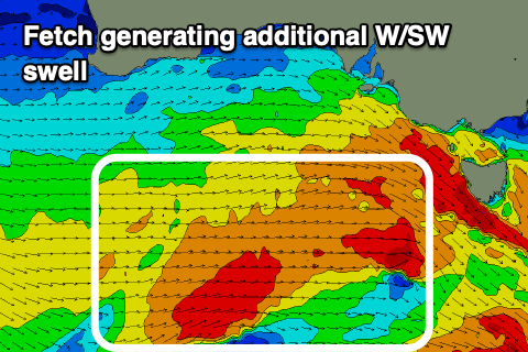
 The groundswell was generated by a vigorous frontal progression that's currently just starting to edge in across us, with fetches of W/SW gales produced just within our swell window the last two days.
We'll see the progression moving further east today with an additional fetch of strong to gale-force W/SW winds projecting towards us today, and then across us tomorrow afternoon. This will extend the life of the swell, but size wise we should see building surf from 1-2ft tomorrow morning to 2ft to possibly 3ft later, then easing from 2-3ft Wednesday.
Winds tomorrow will be good as the swell builds and out of the W/NW, strengthening with the front moving across us, and shifting W/SW mid-afternoon. Wednesday looks better for the size and conditions with a morning W/NW breeze, W/SW into the afternoon.
Thursday looks good with a N/NW offshore but fading 1ft to maybe 2ft of swell, tiny Friday.
From here on there's nothing significant on the cards as the LWT focusses up across Western Australia, pushing the storm track too north of us. Therefore make the most of the coming days, even though not great.

