Fading surf tomorrow, more activity from next week
Southern Tasmania Surf Forecast by Craig Brokensha (issued Monday 24th June)
Best Days: Tuesday, Sunday morning
Recap
A bit of swell on Saturday but onshore, while Sunday was much better with a mix of easing SE swell and new SW swell with light offshore winds.
Today our stronger S/SW groundswell has filled in and built from 2-3ft this morning, with favourable winds most of the day. It should have reached 3-4ft at its peak.
Today’s Forecaster Notes are brought to you by Rip Curl
This week and weekend (Jun 25 - 30)
Today's good pulse of S/SW groundswell is expected to ease through tomorrow and following it there;s nothing too significant on the cards so you'd be best making the most of the small fun waves.
 We should still hopefully see 2ft to possibly 3ft sets tomorrow morning, tiny into the afternoon with a rapid drop in size. Conditions will be great with a persistent N/NW offshore holding all day.
As touched on last update, the storm track is currently too far west and north of our swell windows to generate any size at all on the coast for the rest of the week.
A very inconsistent W/SW groundswell may be seen on Friday but only to 1ft+ or so across Clifton.
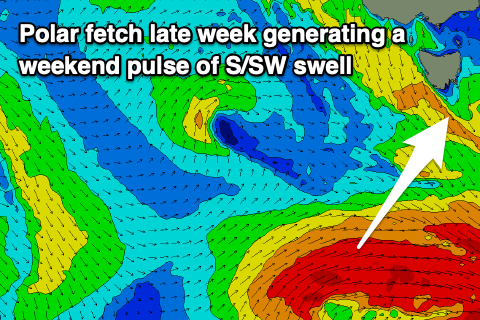
Late in the week, a strong and late forming polar low is forecast to generate a fetch of severe-gale to storm-force W/SW winds right below us.
A small S/SW groundswell is likely from this source, coming in at 2ft across Clifton.
A small mid-latitude low deepening and moving across us at the same time on Sunday will generate an additional short-range W/SW swell to 2ft+ while bringing W/NW tending W/SW winds.
Longer term the Long Wave Trough is expected to move in from the west, bringing with it strong fontal activity. With this some larger swell is on the cards for early next week, but more on this Wednesday.

