Great S/SW groundswell early next week
Southern Tasmania Surf Forecast by Craig Brokensha (issued Friday 21st June)
Best Days: Sunday morning, Monday, Tuesday morning
Recap
Lumpy easing surf yesterday from 2ft, while today a new SE swell has come in a little bigger than expected with 2-3ft sets reported across Clifton. Winds were unfortunately onshore.
Today’s Forecaster Notes are brought to you by Rip Curl
This weekend and next week (Jun 22 - 28)
We should see similar sized 2-3ft surf out of the SE tomorrow morning as the best pulse of SE swell fills in, generated by a low stalling in our swell window the last couple of days.
Unfortunately winds will remain onshore out of the W/SW tending S/SW.
 Sunday will be cleaner with a W/NW wind in the morning and easing SE swell from 2ft, while some new SW groundswell should be in the water to the same size.
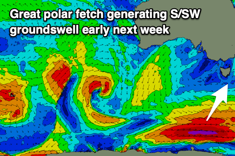
This swell and a larger pulse of Monday will be generated by a great fetch of polar W'ly gales, with the fetch due to reach severe-gale strength south of us on the weekend.
We'll see a strong long-period S/SW groundswell from this source on Monday, building to 3-4ft across Clifton, possibly a little undersized at dawn. Conditions look great with a N/NW tending variable breeze, offshore again from the N/NW Tuesday as the swell eases from 2-3ft.
Longer term we've got some very distant and inconsistent W/SW groundswell in the cards for late next week, but this will be generated in our far swell window and mainly too north of us. The remnants of the storm may bring some better swell next weekend, but more on this Monday. Have a great weekend!

