Small swells from all directions though winds are an issue
Southern Tasmania Surf Forecast by Craig Brokensha (issued Wednesday 19th June)
Best Days: Thursday morning, Sunday, Monday
Recap
A new pulse of inconsistent W/SW groundswell yesterday with clean conditions, increasing a little further today but with onshore winds.
Today’s Forecaster Notes are brought to you by Rip Curl
This week and weekend (Jun 20 - 23)
Today's swell should ease through tomorrow but clean up with a morning W/NW offshore (onshore from late morning) and easing 2ft sets across Clifton, if not for the rare bigger one, tiny Friday.
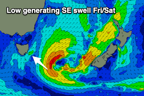
A small new SE swell is on the cards for Friday and Saturday, generated by a low forming off the East Coast and stalling south-east of us tomorrow and Friday.
 A fetch of strong S/SE winds will be positioned just within our swell window, generating a small SE swell that may increase to 1-2ft Friday afternoon and ease from a similar size Saturday.
More exposed spots to the south-east swell will be bigger again. Unfortunately onshore S/SW winds are due on Friday, persisting Saturday as the low remains slow moving away from us during the coming days.
Sunday will become cleaner with a N/NW offshore, NE into the afternoon along with a small new SW groundswell to 1-2ft.
The source of the SW swell will be a polar fetch of W'ly gales, south-west of us on Friday and Saturday, with the swell expected to ease back from 1-2ft on Monday under persistent N/NE winds.
Beyond this the outlook will go quiet as the storm track focusses up towards Western Australia and a strong blocking high steers storms away from us. Therefore make the most of the coming small swells.

