Fun swells on the way from tomorrow
Southern Tasmania Surf Forecast by Craig Brokensha (issued Wednesday 12th June)
Best Days: Thursday, Friday morning keen surfers, Saturday, Sunday
Recap
Tiny surf yesterday and this morning with clean conditions.
Today’s Forecaster Notes are brought to you by Rip Curl
This week and weekend (Jun 13 - 16)
Our small pulse of S/SW groundswell for tomorrow is still on track, generated by a short-lived burst of W/SW gales on the polar shelf south of us.
Satellite observations are significant and we should hopefully see good 2ft sets tomorrow with a persistent N/NW offshore wind.
The swell will then ease into Friday mixed with a small W'ly mid-period swell generated by a front moving across us Thursday evening.
Fading 1-2ft sets are likely with a persistent NW offshore.
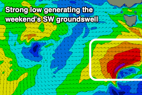
A strong low moving in from our west on Friday will generate a fetch of W/SW gales through our south-western swell window, producing a good pulse of new SW groundswell Saturday.
 We should see Clifton build to 3ft+ into the afternoon and then ease from 2-3ft on Sunday.
A light W/NW tending variable breeze will hopefully be seen Saturday with better N/NW winds Sunday.
Longer term, a significant polar frontal progression firing up in our far western swell window will move closer towards us into early next week.
An initial fetch of distant severe-gale to storm-force W/NW winds, followed by a broader fetch of severe-gale W/SW winds will be projected through our western swell window, weakening south of the country early next week.
A moderate sized long-period W/SW groundswell is due off this source, building Tuesday and peaking Wednesday around 3ft across Clifton. Winds may go onshore but we'll review this Friday.

