Good clean swells for the weekend, slow most of next week
Southern Tasmania Surf Forecast by Craig Brokensha (issued Friday 7th June)
Best Days: Saturday, Sunday, Monday morning
Recap
A mix of building SW and long-period S/SW groundswell were seen through yesterday, biggest into the afternoon and best in protected spots with onshore winds at Clifton.
This swell eased back rapidly into this morning as expected with 2-3ft waves across Clifton with a more favourable W/NW breeze.
Today’s Forecaster Notes are brought to you by Rip Curl
This week and weekend (Jun 8 - 14)
We've got a good new pulse of S/SW groundswell due tomorrow morning across Clifton, generated by a short-lived burst of severe-gale to storm-force W'ly winds on the polar shelf south of us yesterday.
We should hopefully see Clifton holding around 2ft+, easing into the afternoon.
 Conditions should be great all day tomorrow with a persistent N/NW offshore, variable into the afternoon, then NW tending variable NE winds Sunday.
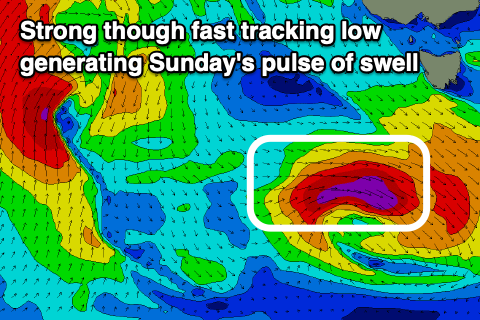
A new SW groundswell is due to build rapidly into Sunday afternoon, generated by a tight and intense low moving in and under us tomorrow.
A short-lived burst of severe-gale to storm-force W'ly winds are forecast to be produced through our western and then south-western swell windows, with the swell spiking Sunday and reaching 3ft+ across Clifton with that variable NE breeze.
The swell will fade rapidly, easing from 2ft or so Monday with a N/NW tending NW breeze.
For the rest of the week there's nothing too significant on the cards until later with a flurry of mid-latitude storms due to bring tricky swell pules from Thursday. It won't be until the weekend that we'll likely see some more reliable SW groundswell moving in, but we'll review this again Monday. Have a great weekend!

