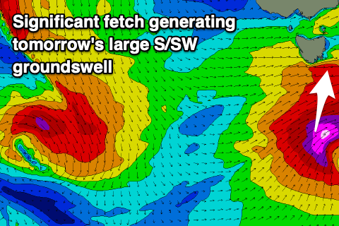
Large short-lived S/SW groundswell
Southern Tasmania Surf Forecast by Craig Brokensha (issued Wednesday 5th June)
Best Days: Tomorrow protected spots, Friday morning, Saturday morning, Tuesday morning
Recap
Sloppy onshore waves yesterday, much cleaner today with a stronger new SW groundswell to 2ft.
Today’s Forecaster Notes are brought to you by Rip Curl
This week and weekend (Jun 6 - 9)
Moving into tomorrow and we look towards our moderate to large long-period SW tending S/SW groundswell event.
Currently a strengthening storm is moving under us, with a fetch of gale to severe-gale W'ly winds being generated south of us, followed by a better aligned fetch of severe-gale to storm-force SW winds in our southern swell window.
 Contrary to model guidance we'll likely see the most size into the afternoon as the S/SW component of the swell fills in, with 3-4ft waves early, building to 4-5ft+ later morning and with onshore SW tending W/SW winds.
A NW tending W/NW breeze is due on Friday as the S/SW groundswell drops rapidly in the wake of the storm moving out of our swell window this evening. There may be the odd 2-3ft wave, but expect it to drop thereafter.
Our secondary long-period S/SW groundswell for Saturday is still on track, but this will be smaller, with a late fetch of severe-gale to storm-force W'ly winds due to form south of us tomorrow evening.
A small 2ft+ wave is likely Saturday morning with great offshore N/NW winds, tending variable NW into the afternoon.
Following this we'll be looking at a tiny run of swell next week apart from a small SW pulse on Tuesday. This should be produced by another strong polar low, though size wise we're looking at sets to 2ft with a N/NW offshore. More on this Friday.


Comments
Any reports on how big it got through the day? Satellite observations of the fetch were very impressive.
Kelvedon 3-4' 1-3pm. Smaller in the morning.
From what I hear it was an unusual swell in that it got into places you wouldn't expect and barely showed in others that it should have. Why that would be I have absolutely no idea.
Thanks for these reports too, I may not comment but I certainly read them!
Thanks for that, yeah the unusuality of the swell is due to its long period nature which always do weird things on coasts that aren't used to them. Funnel and focus into some breaks while being steered away from others.