Plenty more swell and wind to come
Southern Tasmania Surf Forecast by Craig Brokensha (issued Monday 3rd June)
Best Days: Wednesday, Thursday afternoon protected spots, Friday morning, Saturday
Recap
Friday's S/SE groundswell eased back from a clean 3ft on Saturday, back from a smaller 2ft on Sunday.
Today a strong low has moved across the state bringing onshore winds and a poor quality increase in S'ly windswell.
Today’s Forecaster Notes are brought to you by Rip Curl
This week and weekend (Jun 4 - 9)
Winds will remain onshore tomorrow with a mix of easing S/SW windswell and new mid-period S/SW swell ahead of a better SW groundswell on Wednesday.
The mid-period S/SW swell will be generated by strong S/SW winds at the final stages of a stronger polar front that generated a good W'ly fetch of gales south of WA this morning.
Small 1-2ft waves should be seen tomorrow, with Wednesday providing more size to 2ft.
 Conditions should become cleaner Wednesday with a W/NW offshore, giving into a W/SW change later in the day.
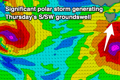
This change will be linked to a significant and strengthening polar storm directly south of us on Wednesday.
We're expected to see a fetch of severe-gale to storm-force W/SW tending SW winds projected under the state and through our southern swell window. A large and powerful SW tending S/SW groundswell should fill in Thursday and build to 4-5ft across Clifton but with strong onshore SW tending weaker W/SW winds.
Friday will then be clean with a NW offshore but the swell will drop rapidly and only likely be around 2ft in the morning.
Following this storm a very strong but south-east tracking polar front is forecast to move in from WA, with it due to generate a burst of severe-gale to storm-force W'ly winds on the polar shelf of us later this week.
Another fleeting pulse of S/SW groundswell is due off this front, coming in Saturday morning and offering 2-3ft sets across Clifton with a N/NW offshore.
After this there's plenty of activity on the cards for next week, but it looks to be mostly out of the west as strong frontal systems fire up towards Western Australia. More on this Wednesday though.

