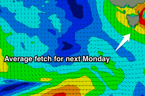
Fun easing S/SE swell, average early next week
Southern Tasmania Surf Forecast by Craig Brokensha (issued Friday 31st May)
Best Days: Saturday morning, Sunday
Recap
A mix of easing W/SW groundswell and new S/SW mid-period swell with early offshore winds, onshore into the afternoon.
Today our stronger S/SE groundswell is providing more size with 3-4ft sets reported off Clifton with onshore winds, best in protected spots.
Today’s Forecaster Notes are brought to you by Rip Curl
This weekend and next week (Jun 1 – 7)
Our current S/SE groundswell was generated by a great fetch of polar gale to severe-gale S/SE winds, and while this has since gone, a secondary fetch of strong S'ly winds in our southern swell window will slow the easing trend in size over the weekend.
 We should still see sets to 3-4ft across Clifton tomorrow morning, easing slowly through the day and then down further from 2-3ft on Sunday.
Conditions will improve across Clifton tomorrow morning with a light W/NW breeze, shifting W/SW into the afternoon.
Sunday looks great with all day offshore N/NW winds.
As talked about in Wednesday's notes, a strengthening low will move in and across us on Sunday evening, bringing a strong S/SW change and local and weak increase in S'ly windswell.
With wind strengths not reaching gale-force no major size or power is due, with a junky 3ft+ of swell due to develop Monday with those strong S/SW winds.
The swell should start to ease Tuesday as winds remain onshore, with a possible more significant S/SW groundswell event on the cards for later in the week. This will be from a late developing though significant polar front, though we'll have to review this Monday. Have a great weeekend!

