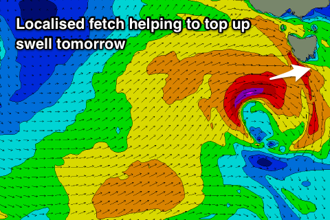
Strong W/SW swells tomorrow, easing slowly and tending more SW
Southern Tasmania Surf Forecast by Craig Brokensha (issued Monday 8th April)
Best Days: Tuesday morning, keen surfers Wednesday, Thursday morning, Friday
Recap
A clean tiny 1-1.5ft wave Saturday morning, building into the afternoon and good yesterday with all day offshores.
Today a new W/SW swell should of started to show into the afternoon, but it's hard to confirm without Cape Sorell wave data. The Victorian coast is building though which is promising.
Today’s Forecaster Notes are brought to you by Rip Curl
This week and weekend (Apr 9 - 14)
The first pulse of W/SW groundswell that's on the build today was generated since the middle of last week by a slow moving polar low south-west of WA, projecting slightly more east-northeast towards the Bight on the weekend.
 Tomorrow's reinforcing swell was generated by a secondary front moving on top of the active sea state of the first storm, but really north in latitude, right on the edge of our western swell window.
This isn't ideal at all, but the system has since dipped back south-east and generated a fetch of W/SW gales directly west-southwest of us this afternoon.
This should help boost the size of tomorrow's swell with sets to 3ft across Clifton. Winds are still a bit dicey and not perfect but good with a morning W/NW breeze, tending SW into the afternoon.
Wednesday looks a bit suss with a W/SW breeze as the swell continues to ease, softened and tending more SW in direction due to an elongated fetch of strong SW winds forming in the wake of today's low.
Easing surf from 3ft is expected though bumpy and lumpy, cleaner and maintaining 2ft+ Thursday as good fetch of W'ly winds pass under us Wednesday, keeping the swell up.
Smaller surf is due into Friday with a good morning offshore N/NW wind.
Longer term the storm track will be focussed up towards WA resulting in tiny to small W'ly swells all of next week. More on this Wednesday.

