Multiple westerly swell pulses, solid through early next week
Southern Tasmania Surf Forecast by Craig Brokensha (issued Wednesday 3rd April)
Best Days: Thursday morning, Sunday morning, Monday, Tuesday morningm, Wednesday morning
Recap
Fun clean easing surf from 2ft yesterday morning, still hanging in at 1-1.5ft this morning with a great sunrise. A strong onshore change has since moved through and we should be seeing a local increase in W/SW swell this afternoon.
Today’s Forecaster Notes are brought to you by Rip Curl
This week and next (Apr 4 - 12)
The strengthening front linked to today's building swell is a little better than forecast on Monday and with this we should see 2-3ft waves early tomorrow. Conditions should be clean with a light N/NW offshore, tending E/NE into the afternoon and freshening.
Friday looks tiny with fading 1-1.5ft sets max and a strengthening N/NE breeze.
Saturday morning still looks flat, but a strong and east-southeast tracking low moving across us through the day should produce a burst of W/SW gales through our western swell window through the morning, producing a late kick in W/SW swell to 2ft on dark, easing rapidly from 2ft to possibly 3ft Sunday morning. Conditions will be great with a persistent N/NW offshore.
 Moving into early next week, and our significant frontal progression through the Southern Ocean is still on track with an initial strong polar low forming around the Heard Island region due to produce a distant fetch of severe-gale to storm-force W/SW winds through our western swell window, moving closer while weakening on the weekend.
The swell from the low should build Monday from a small 1-2ft early to 2-3ft later in the day along with a N/NW offshore.
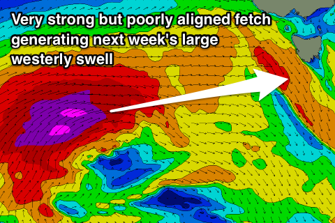
A much stronger but poorly aligned front will produce a storm-force W/SW fetch on the edge of our western swell window Sunday and Monday before moving across us in a much weakened form on Tuesday.
A larger long-period and very acute W'ly swell is due from this storm, arriving late Monday but peaking Tuesday to 3-4ft with a morning W/NW breeze, giving into a gusty SW change. The easing trend will be slow as the swell swings more W/SW into the middle to end of the week, but more on this Friday.

