Windy weekend, good swell with better conditions early next week
Southern Tasmania Surf Forecast by Craig Brokensha (issued Friday 29th March)
Best Days: Protected spots tomorrow morning, Monday morning, Tuesday
Recap
Tiny surf this morning but a new W/SW groundswell should be starting to show this afternoon with favourable offshore winds.
Today’s Forecaster Notes are brought to you by Rip Curl
This weekend and next week (Mar 30 – Apr 5)
Cape Sorell is on the way up and this is from a new long-period W/SW groundswell that was generated through the middle of this week, south of WA. A good fetch of gale-force W/SW winds were generated in our western swell window, with the storm projecting slightly towards us before weakening.
 A fun W/SW swell should reach an easy 2ft this afternoon across Clifton, peaking tomorrow morning to 2ft to occasionally 3ft, easing through the day and smaller Sunday morning.
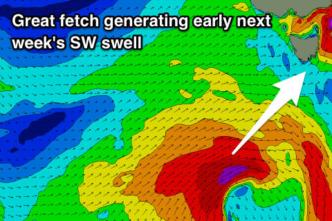
Winds look dicey and out of the W through the morning, tending SW as a strong frontal system pushes across us. This will leave gusty S/SW winds into Sunday morning but followed by a mix of building windswell and new SW groundswell that will peak Monday morning.
The source of the groundswell will be a frontal system come low moving in from the west on the weekend, with a pre-frontal fetch of strong to gale-force W/NW winds being followed by a post-frontal fetch of gale-force SW winds.
The swell should peak Monday morning to a good 3ft across Clifton (if not for the odd bigger one) and a shift in winds is likely to the W/NW, giving into afternoon sea breezes.
Tuesday will be nice and clean with a light N/NW offshore and fun easing sets from 2ft, tiny into Wednesday.
For the rest of the week there's nothing significant on the cards, but a deepening mid-latitude low moving in Friday evening looks to produce a S/SW windswell event next weekend. More on this Monday. Have a great weekend!

