Lots of swell to end the week
Southern Tasmania Surf Forecast by Craig Brokensha (issued Wednesday 18th July)
Best Days: Thursday, Friday morning, Saturday protected spots, early Sunday
Recap
Yesterday's flukey long-range and inconsistent groundswell didn't really show, and this morning we've got a touch more action, but mostly tiny waves with a small mid-period W/SW swell as expected.
The new long-period energy due this afternoon is showing nicely on the Cape Sorell wave buoy and with this we should see better sets building towards 3-4ft by dark today as winds remain offshore.
Today’s Forecaster Notes are brought to you by Rip Curl
This week and weekend (Jul 19 - 20)
Want to receive an email when these Forecaster Notes are updated? Then log in here and update your preferences.
Later today's strong increase in long-period W/SW groundswell is expected to ease back through tomorrow from 3ft to maybe 4ft at dawn, but at the same time we'll see a reinforcing pulse of long-period W'ly swell filling in.
This has been generated by a severe low forming under WA, tracking east-southeast and into our swell window last night and early this morning.
A fetch of gale to severe-gale W'ly winds have been produced just in our western swell window, generating a fresh pulse of swell keeping wave heights around 3ft most of the day under gusty NW winds.
 The swell is due to ease later in the day, with a temporary low point Friday morning ahead of some good new W/SW swell later in the day and Saturday morning.
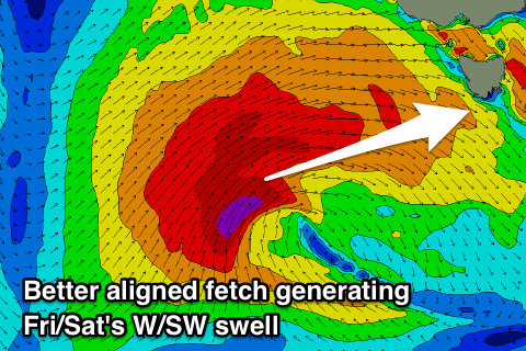
This better aligned W/SW swell will be generated on the backside of the frontal progression linked to tomorrow's swell, with a fetch of gale to severe-gale W/SW winds being projected nicely through our western swell window tomorrow before breaking down on Friday.
The front linked to this swell will push across us on Friday morning, bringing gusty SW winds as the swell builds along with some windswell, with onshore surf building to the 3ft range.
The weekend looks much better for surfing with a mix of SW and W/SW swells from 3ft+ along with a morning W/NW breeze, tending more W'ly through the day.
All day offshore N/NW winds are expected on Sunday but with a small fading 1-2ft wave.
Longer term we've got more less consistent long-range W/SW groundswells on the cards for action south-west of WA. None of this looks sizeable, with some more localised swell a possibility on Wednesday/Thursday.

