Good swell for the weekend with funky winds
Southern Tasmania Surf Forecast by Craig Brokensha (issued Friday 13th July)
Best Days: Saturday, Sunday morning, Tuesday morning keen surfers, Wednesday morning, Thursday
Recap
Small clean fun leftover waves yesterday morning, while this morning the surf started tiny, but some new long-period SW groundswell should of started to show later today, and it's hit the Cape Sorell wave buoy.
Today’s Forecaster Notes are brought to you by Rip Curl
This weekend and next week (Jul 14 - 20)
Want to receive an email when these Forecaster Notes are updated? Then log in here and update your preferences.
Late today's increase in swell is expected to peak tomorrow, with no change from the week's forecasts with good strong 3ft to occasionally 4ft sets due across Clifton early, easing steadily through the day, down from 2ft Sunday morning.
 Winds are now looking a touch dicier with more variable breezes and slightly lumpy conditions due at dawn, before winds tend E'ly.
Sunday will be cleaner with a light NW tending variable breeze.
The surf is due to be mostly tiny into Monday with all day offshores, while a new inconsistent long-range W/SW groundswell may be seen Tuesday morning.
This swell was generated in our far swell window in the Heard Island region through this week and is only likely to provide very infrequent 1-2ft sets across Clifton. Gusty N/NW winds should create clean conditions though for desperate surfers and beginners.
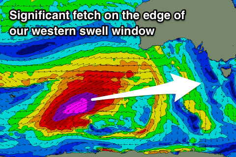
Now, our attention turns to the significant polar frontal progression that's currently developing in the Southern Ocean south-west of WA.
Most of this storm activity will form in our far swell window, and when the strongest storm-force W/SW fetch develops, it will project up towards WA and through the edge of our western swell window.
Still a large active sea state will be produced by a well aligned polar fetch of severe-gale W/NW tending W/SW winds, followed by those storm-force W/SW winds projecting up into the Bight.
This will produce XXL surf across southern Australian with moderate sized and inconsistent sets pushing into our region on Wednesday.
Clifton should build to an infrequent 3-4ft through the afternoon, with possibly the odd bigger bomb later in the day.
Conditions will be best through the morning with a gusty NW tending W/NW breeze, ahead of a W/SW change through the early-mid afternoon.
Thursday looks great with all day offshore N/NW winds and easing surf from 3ft+.
Longer term some new W/SW groundswell may be seen Saturday from a strong mid-latitude low pushing in from the west, but we'll have a closer look at this Monday. Have a great weekend!

