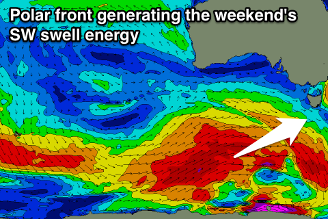
Smaller swells this week, larger from the weekend
Southern Tasmania Surf Forecast by Craig Brokensha (issued Monday 21st August)
Best Days: Tuesday morning, early Wednesday keen surfers, Thursday morning, late Friday, Sunday
Recap
Friday's good increase in S/SW swell eased back from the 3ft range Saturday morning but conditions weren't great with overnight onshores and a short-lived W/NW'ly not really cleaning up the swell.
Yesterday was much better with clean fun 2ft surf. Today was similar with some reinforcing SW energy and clean fun waves.
This week and weekend (Aug 22 - 27)
The swell is due to drop slightly into tomorrow morning, back to 1-2ft across Clifton and possibly tiny through the afternoon. Conditions will be great with all day offshore winds.
A new mix of swells for Wednesday look to be spoilt by onshore winds now. A vigorous but distant polar frontal progression late last week has generated W/SW energy in the 2ft range, but we may see winds swing onshore shortly after dawn.
The hi-res models still have an early W/NW'ly which is good, giving into a shallow SE change.
 The surf is then expected to ease through Thursday from 1-2ft with funky W/NW-W/SW winds.
Of greater importance is the development of a stronger polar frontal progression in our swell window mid-late week.
As touched on last week we're expected to see a pre-frontal fetch of gale to severe-gale W/NW winds generating a good W/SW groundswell for Friday afternoon, while a broader and better positioned fetch of post-frontal gale to severe-gale W/SW winds will generate a larger SW groundswell for Saturday and Sunday.
We should see Clifton build late Friday to 2ft, with a much better increase in size Saturday to 3-4ft+ through the afternoon, easing from a similar size Sunday.
Unfortunately winds look onshore Saturday in the wake of the front, with better offshores Sunday.
We'll see plenty more swell into next week as secondary polar fronts fire up in our swell window, but more on this Wednesday.

