Great S'ly swell, with smaller W'ly swell next week
Southern Tasmania Surf Forecast by Craig Brokensha (issued Wednesday 26th July)
Best Days: Thursday, Friday morning, Monday morning
Recap
A strong new SW groundswell seen later Monday held into yesterday with solid clean 3ft waves across Clifton.
Today a reinforcing S/SW swell was spoilt by onshore winds as the front linked to it clipped the state.
This week and weekend (Jul 27 - 30)
Tomorrow is looking much better for a surf as a new S'ly groundswell fills in, generated by a burst of strong S'ly winds at the base of the polar storm responsible for the last two days of swell.
We should see the swell filling in through the morning, pulsing to a good 3ft on the sets, easing back from 2-3ft Friday morning.
Conditions look great with a NW tending N'ly breeze tomorrow and then NW winds Friday morning ahead of a mid-afternoon SW change.
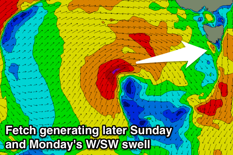
 Our next swells are due out of the west, as a vigorous mid-latitude low forms south-west of WA and broadens while pushing east over the coming days.
The winds within the low will sit just too far north of our western swell window right until Saturday, when a weakening fetch of W/SW gales should just slip south enough.
This should result in a late increase in size Sunday possibly yo 1-1.5ft, with a peak Tuesday to 1-2ft.
Conditions are looking clean for the most part ahead of a SW change Monday afternoon.
Longer term tiny surf is due for the rest of the week, but more on this Friday.


Comments
hey craig looks like youre getting waves up in nsw !!
when do you reckon the swell will peak tomorrow ? models seem to disagree ..
cheers !