Average swells with less than ideal winds
Southern Tasmania Surf Forecast by Craig Brokensha (issued Monday 1st August)
Best Days: Desperate surfers Tuesday and Wednesday mornings, Saturday
Recap
A good new pulse of SW groundswell Saturday morning to the initial forecast of 3-4ft through the week with improving conditions under an offshore wind. The swell eased steadily through the day, with small easing sets from 2ft Sunday morning.
Today the surf was tiny and back to 1-1.5ft.
This week (Aug 2- 5)
This coming forecast period isn't too flash at all. Firstly a very west but large groundswell impacting the West Coast tomorrow should come in at a very infrequent 1-2ft across Clifton tomorrow morning, but winds will be average, from the W early, tending SW through the late morning.
 The deepening cut-off low that was forecast to develop in our region mid-week has now totally changed, with a short-lived Tasman Low expected to form out of our swell window to the east.
This will result in no major swell being generated with a weak SW windswell Wednesday to 2ft, easing through the day and further Thursday. Onshore S/SW winds are due Wednesday (possibly W'ly early) and then light variable S/SE winds Thursday.
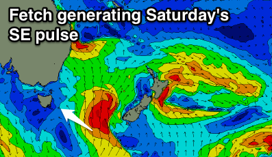
The only other possible source of swell for the rest of the forecast period, is a polar front projecting north towards the southern Tasman Sea, through our south-eastern swell window on Friday. This should produce a small SE swell that's expected to fill in Saturday, reaching 2ft across Clifton with morning offshores, easing from 1-2ft Sunday.
Into next week there's nothing significant at all with a blocking high shutting down our main swell windows until later next week. More on this Wednesday though.

