Easing swell into the end of the week, good S/SE groundswell Sunda
Southern Tasmania Surf Forecast by Craig Brokensha (issued Monday 18th July)
Best Days: Thursday, Saturday morning, Sunday, Monday, Tuesday onwards
Recap
A slow start to yesterday morning but into the afternoon a good kick to 2-3ft was seen with favourable winds.
This swell eased back to the 2ft range this morning, but a secondary larger kick in size is due from a vigorous front generating a fetch of severe-gale to storm-force W/SW winds through our swell window.
Clifton should kick to 3-4ft by dark with favourable winds.
This week and weekend (Jul 21 - 24)
This afternoon's late kick in W/SW groundswell will peak overnight and ease back steadily from 3ft across Clifton tomorrow morning, smaller into Friday morning. Conditions will be good with offshore N/NW winds tomorrow and then N/NW tending W'ly winds Friday.
The weekend is still looking quite dynamic but not as big as forecast on Monday.
A multi-staged low will move across us Friday afternoon, with an additional fetch of strong W/SW winds being aimed under us into the evening, tending more SW through the day Saturday.
This will result in a small weak WSW swell for Saturday morning to 1-2ft or so, building later in the day to 3ft on the sets. Winds may be W'ly early, tending SW through the afternoon.
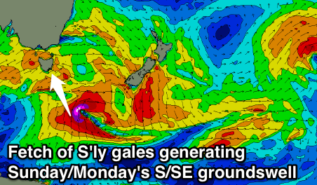
 Into Sunday a stronger pulse of S/SE groundswell is expected, produced by a better aligned and stronger fetch of severe-gale to sub-storm-force S'ly winds south-southeast of us Friday evening and Saturday.
The S/SE groundswell is due to arrive through Sunday and build to 3-5ft through the afternoon across Clifton, easing back from 3-4ft Monday morning, smaller into Tuesday.
Offshore NW winds will create clean conditions Sunday and Monday morning before shifting W'ly through the afternoon.
Next week onwards (Jul 25 onwards)
From Tuesday next week we've got a very active period of surf ahead with an elongated node of the Long Wave Trough stretching across our swell window due to project back to back to back polar frontal systems through our swell windows.
Various pulses of moderate to possibly large W/SW groundswell are due from Tuesday through the end of next week with generally favourable winds, but we'll have another look at this Friday.

