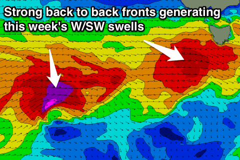
Good fun W/SW swells this week, dynamic weekend
Southern Tasmania Surf Forecast by Craig Brokensha (issued Monday 18th July)
Best Days: Tuesday, Wednesday, Thursday, the weekend
Recap
Small to tiny surf all weekend to 1-1.5ft both days. Today the surf was back to a tiny 0.5ft with no real decent options.
This week (Jul 19 - 22)
The coming few days are looking more active than forecast on Friday with a couple of better aligned and strong mid-latitude fronts due to push through our western swell window.
Currently the first system is strengthening while approaching us with a fetch of gale to severe-gale W/SW winds passing under us this evening and tomorrow morning.
 A good kick to 2-3ft is due across Clifton through the day tomorrow, easing back into Wednesday morning.
A secondary pulse is then expected through Wednesday from a secondary front producing stronger severe-gale to storm-force W/SW winds through our swell window.
The mid-late afternoon should kick to 3-4ft, easing back from 3ft+ Thursday morning, smaller into Friday.
Winds tomorrow look to improve with a gusty W/NW tending lighter NW breeze and then offshore NW winds through Wednesday and Thursday. Friday will see stronger N/NW winds develop as a vigorous mid-latitude low moves in from the west.
This low will be really intense and will direct an initial fetch of storm-force W/SW winds being generated right under us Friday night and early Saturday, followed by a better aligned fetch of severe-gale SW winds projecting into us through the afternoon and then storm-force S/SW winds at the base of the low.
This will kick up a short-range W/SW swell for Saturday morning, then some better SW swell through the afternoon and S'ly groundswell Sunday afternoon and Monday.
The models are still moving around regarding the structure of the low and the sizes and timings of these swells, so we'll have to have a closer look at this on Wednesday.

