Large W/SW swell for tomorrow, fading quickly Friday
Southern Tasmania Surf Forecast by Craig Brokensha (issued Wednesday 13th July)
Best Days: Thursday, Friday, early Saturday
Recap
Tiny waves yesterday while today a strong W/SW groundswell is building across the South Arm, with even small peelers in protected spots.
This week and weekend (Jul 14 - 17)
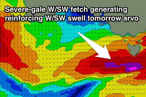
A vigorous cold front pushing across us today bringing low level snow and today's building W/SW swell will be followed very closely by a secondary system tomorrow, with a fetch of severe-gale W/SW winds generated right underneath us.
 This will produce a reinforcing W/SW groundswell for tomorrow afternoon, with the morning coming in around 4-5ft across Clifton, maintaining a similar size into the afternoon before easing back quickly from 3-4ft Friday morning.
Come Saturday not much size is left at all with 1-2ft leftovers, and some new W/SW swell from pre-frontal fetches of W/NW gales over near WA doesn't look to get above 1ft Sunday.
Conditions will be best in protected locations tomorrow morning with a fresh W/NW breeze, tending W/SW through the day.
Friday should then see W/NW winds most of the day and then all day offshores over the weekend.
Longer term there's nothing significant due until Tuesday/Wednesday next week when we may see some good SW groundswell from a strengthening polar front below us, but more on this Friday.

