Small fun weekend, stormy next week
Southern Tasmania Surf Forecast by Craig Brokensha (issued Friday 6th May)
Best Days: Saturday, Sunday morning
Recap
A gradual easing trend has been seen the last few days after Wednesday's large W/SW groundswell. Offshore winds have kept conditions clean all day as well.
This weekend and next week (May 7 - 13)
A couple of small pulses of swell are due over the weekend, the first tomorrow from the SW, keeping 2ft sets hitting Clifton. This was generated on the tail of the vigorous frontal progression responsible for this weeks swell, but a new W/SW swell is also due later in the day, peaking Sunday morning from a zonal frontal system currently pushing in from the west.
Again this should keep 2ft sets hitting Clifton Sunday morning before fading through the afternoon and becoming tiny Monday.
Clean conditions are due all tomorrow with a N/NW tending variable wind and then Sunday looks better now with a light NE'ly ahead of a freshening E/SE'ly.
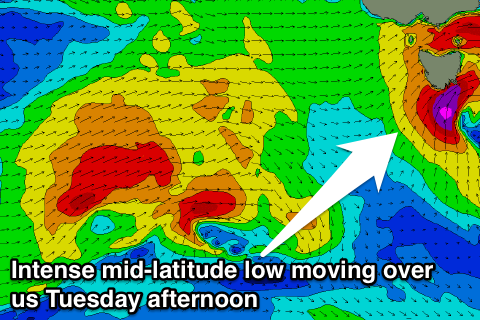
This freshening onshore wind will be linked to a deepening mid-latitude low over South Australia, but it doesn't look to generate any swell for us until Tuesday evening, when it finally drifts south-east.
 As it moves across us, a fetch of severe-gale S/SW winds are forecast to be aimed up into us Tuesday afternoon, kicking up a late large increase in stormy swell. The change will likely be late to generate enough size to surf protected spots, and will ease rapidly overnight into Wednesday morning as winds tend back to the NW.
Later in the week a secondary more significant polar system should produce some better SW groundswell Thursday and Friday but the models diverge on the make up of this system. Check back here Monday for more info on this. Have a great weekend!

