Strong building W/SW swell later tomorrow, peaking Wednesday
Southern Tasmania Surf Forecast by Craig Brokensha (issued Monday 2nd May)
Best Days: Tuesday, Wednesday, Thursday, Friday, Saturday morning
Recap
Tiny waves Saturday while a strong front passing under us kicked up a small average increase in swell Sunday to the 2ft range. This swell has actually held into today a lot better than expected with 2-3ft sets under an offshore wind, but we've got much more significant developments to come.
This week (May 3 - 6)
From tomorrow we'll see wave heights start to climb due to a vigorous and broad polar frontal progression occuring to our west.
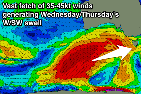
 On Saturday night an intense polar low fired up in the Heard Island region, generating a fetch of severe-gale to storm-force W'ly winds in our far swell window before projecting while widening in scope up towards the Bight.
Currently a vast fetch of severe-gale SW winds are being aimed through our western swell window, with a large long-period W/SW groundswell due to start building tomorrow afternoon ahead of a peak Wednesday.
While the peak of swell is due through Wednesday, a persistent fetch of SW gales anchored to the polar shelf will remain aimed through our swell window and project slightly east through tomorrow and Wednesday.
This will keep the swell up through Thursday, while a secondary embedded front generating a fetch of severe-gale W/NW winds through our western swell window and under us early Thursday should also produce a reinforcing W/SW swell for Thursday afternoon and Friday morning.
Size wise, tomorrow is hard to pin down how much swell will spread into the South Arm, but 2ft+ sets are likely, building later in the day to 3ft+ if not 4ft ahead of a peak Wednesday to 3-5ft across Clifton.
Thursday morning should still be around 3-4ft, easing through the day and then down further from 2-3ft Friday morning.
Conditions are looking for the most part great with a N/NW tending gusty W/NW breeze tomorrow and then W/NW tending NW winds through Wednesday afternoon.
Thursday should be great all day with N/NW offshores and then W/NW to NW winds on Friday.
Into the weekend a small reinforcing SW swell is due Saturday morning to 2ft with offshores, while a front crossing the state on Sunday/Monday may stall and form into a deep powerful low south of us early next week. We'll have a closer look at this on Wednesday.

