Nothing significant until Wednesday next week
Southern Tasmania Surf Forecast by Craig Brokensha (issued Friday 29th April)
Best Days: Later Tuesday, Wednesday, Thursday, Friday morning
Recap
Tiny waves both yesterday and today with average winds on the former and cleaner conditions today.
This weekend and next (Apr 30 – May 6)
Tiny surf will continue through the weekend with a south-east dipping cold front across the state generating a slight pulse in W/SW swell for later Sunday and Monday morning only to 1ft or so.
Of much greater significance are the developments through this weekend and early next week.
The large expansive and vigorous storm forming in the Southern Ocean is now expected to sit a touch further south and lower, more in our swell window.
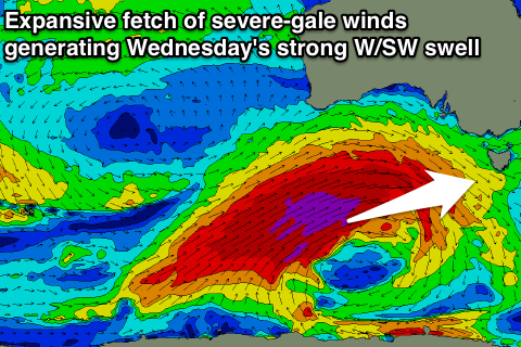
 A vigorous polar low is forecast to develop around the Heard Island region tomorrow evening, generating a polar fetch of severe-gale to storm-force, broadening and weakening while projecting north-east towards the Bight and stalling.
This will produce an XXL swell for exposed coasts across SA, Vicco and our West Coast, with the W/SW groundswell filling in later Tuesday and peaking Wednesday to a strong 3-5ft across Clifton.
The stalling and slowly weakening fetch of SW gales will slow the easing trend into the end of the week, back from 4ft or so Thursday further down from 2-3ft Friday.
Now winds are looking great with offshore NW tending W/NW winds as the swell builds Tuesday with N/NW tending NW winds at the peak of the swell. Offshore winds are then due again Thursday ahead of a change possibly Friday. More on this Monday though.

