Fun waves most of the week, best Sunday
Southern Tasmania Surf Forecast by Craig Brokensha (issued Monday 11th April)
Best Days: Early Tuesday, Wednesday morning, Thursday, Friday morning, Sunday
Recap
A good kick in SW groundswell was seen Saturday to 3ft with all day offshores, easing back a touch into Sunday morning as we fell in between swells to 2-3ft.
Conditions were clean again but tricky with really strong offshores, and a new kick in swell later in the day.
Today a larger pulse of SW groundswell due across the South Arm didn't quite come in as large as expected, with the frontal system generating it being a touch weaker than forecast on Friday. Still a solid kick was seen through the day but protected spots were the only real option with SW winds.
This week and weekend (Apr 12 - 17)
Today's swell should ease overnight and should continue to drop through tomorrow from the 3ft range, with better W/NW winds early, swinging back onshore from the SW mid-morning.
Wednesday won't drop below 2ft, from weak background frontal activity through our swell window, with morning NW winds again, shifting SE into the afternoon.
Our long-period SW groundswell for Thursday has unfortunately been downgraded a little with the vigorous fetch of pre-frontal W/NW winds through the south-east Indian Ocean linked to it, only reaching the severe-gale range instead of storm-force.

This will result in a less consistent and smaller swell, peaking Thursday morning to an inconsistent 2ft+ across Clifton with offshore N/NW winds ahead of weak afternoon sea breezes.
A drop in size is expected into the afternoon, but a late forming and intense polar low to our south on Tuesday night should keep infrequent 2ft sets hitting Clifton out of the S/SW Friday with NW winds.
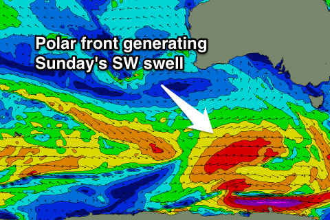
Longer term a better SW groundswell is due on Sunday, produced by a not overly strong but persistent polar front travelling along the polar shelf from south-east of Heard Island, under us Saturday morning.
Good 3ft sets are due across Clifton when the swell peaks, with a light NW offshore, tending SE into the afternoon. More on this Wednesday.

