Plenty of swell to come with favourable conditions

Southern Tasmania Surf Forecast by Craig Brokensha (issued Wednesday 6th April)
Best Days: Every day over the coming period besides Friday
Recap
Small clean 1-2ft waves yesterday morning, but today started around a similar 1-2ft. The swell should of kicked to a better 2ft to possibly 3ft into this afternoon though with a new mix of W/SW swells. Conditions are still nice as well with a moderate to fresh NW breeze.
This week and weekend (Apr 7 - 10)
Any increase in swell today will be short-lived, with a drop due back from a clean 2ft early tomorrow, tiny into the afternoon.
Friday is expected to remain tiny but clean with NW tending W/NW winds.
Our SW groundswell pulses for Saturday are still on track, but with just a slight downgrade on the expected size.
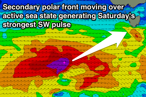 Over the coming days, back to back polar fronts will generate two closely spaced SW groundswell pulses for Saturday, the first for dawn and second larger pulse for mid-morning.
The first front will set up an active sea state for the second front to quickly piggy-back over the top of, generating a good moderate sized SW groundswell pulse, peaking around a good 3ft across Clifton.
Conditions look excellent with a N/NW tending NW breeze, while come Sunday morning conditions should be clean again but the swell smaller and around 2ft+.
A flurry of secondary polar frontal activity is due to generate some additional SW groundswell for Sunday afternoon and Monday to a similar size, but this will be overridden by a larger short-range SW swell.
The short-rage swell will be generated as one of the polar front strengthens right on our doorstep, projecting a fetch of SW gales up and into us through Sunday.
This will bring an afternoon SW change Sunday and likely a late kick in swell to the 4ft range, peaking early Monday morning to 3-5ft, easing off through the day. Protected locations will be the pick with a gusty W/SW breeze, due to swing more W/NW through the day as the swell eases.
Longer term we've got a better aligned and stronger polar front due early next week, aiming a fetch of severe-gale SW winds through our southern swell window.
If this comes off we'll see a moderate to large S/SW groundswell for later Tuesday/Wednesday next week. More on this Friday though.