Building W/SW swell tomorrow, peaking Sunday morning
Southern Tasmania Surf Forecast by Craig Brokensha (issued Wednesday 30th March)
Best Days: Saturday morning, Sunday, Monday, Tuesday afternoon, Wednesday
Recap
Tiny clean waves yesterday, but a strong new swell kicked into the late afternoon as winds tended variable.
This morning the swell was a little inconsistent but around a good 2ft on the sets, a bit under the 2-3ft expected early. Conditions are great though with a N/NW offshore.
This weekend and next week (Apr 2 - 9)
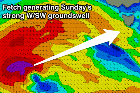
There's been no real change to the weekend outlook, with a vigorous polar frontal progression firing up under the country, generating some large W/SW groundswell energy for our West Coast, filtering in across the South Arm slowly tomorrow ahead of a peak Sunday.
Tomorrow should start slow with clean 2ft waves, but an onshore change is due through the day as the swell builds to 3ft on the sets later in the day.
 Sunday's largest increase is being generated by a fetch of severe-gale W/SW winds firing up south of WA, projecting west through our western swell window, over an already active sea state.
This should provide solid 3-5ft waves across Clifton through the morning, easing back into the afternoon, and then further down from 2ft Monday morning.
Conditions should improve Sunday with an early W'ly due to swing more W/NW through the morning, persisting into the afternoon. Monday should then also be good with NW offshores, tending variable into the afternoon.
Further on, the trailing frontal activity isn't due to be as strong or favourable, with a small inconsistent increase due later Tuesday and Wednesday morning to the 2ft range.
Longer term we should see some better frontal activity firing up through the second half of the week, but check back here Monday for another update. Have a great weekend!

