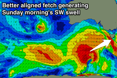
Good swell late tomorrow and early Friday, large Sunday morning
Southern Tasmania Surf Forecast by Craig Brokensha (issued Wednesday 30th March)
Best Days: Late Thursday, Friday morning, early Saturday, Sunday, Monday, Tuesday onwards
Recap
A further drop in swell from Monday with clean 2ft waves most of yesterday across the South Arm, back to a smaller 1-2ft today. Conditions were again clean before fresher sea breezes kicked in.
This week and weekend (Mar 31 – Apr 3)
Tomorrow morning is expected to start out tiny, but into the late afternoon/evening a strong pulse of SW groundswell is due, peaking overnight and easing Friday.
This swell was produced by a strong polar low firing up south-west of WA, with satellite observations recording core winds up to 50kts.
The swell will be a little inconsistent but should reach 2-3ft by dark tomorrow, easing back from 2ft to possible 3ft early Friday morning.
Winds should be offshore most of the day before afternoon sea breezes try and kick in, likely resulting in variable winds, while Friday will be offshore all day from the N/NW tending NW.
Into the weekend we'll see a vigorous and multi-phased frontal progression firing up under WA and pushing east, following a strong node of the Long Wave Trough.
 The initial frontal activity will be too far north of our swell window before dipping further south and passing under us on Saturday. A fetch of gale to severe-gale W/SW winds should be generated through our south-western swell window, producing a strong W/SW groundswell pulse for Sunday morning.
Before this though we'll see a gradual increase in W/SW swell Saturday, likely from 2ft in the morning, to 2-3ft into the late afternoon before peaking Sunday morning with the W/SW energy to 3-5ft.
A gradual drop in size is due through the day, with much smaller 2ft leftovers into Monday morning.
Conditions are looking great Saturday morning with an early W/NW breeze, but a W/SW change is due through the mid-morning.
Sunday looks excellent with offshore NW tending W/NW winds.
Next week onwards (Apr 4 onwards)
A temporary low point in energy is due through Tuesday, but some fun new SW pulses are due through the middle to end of the week from a flurry of small but good looking polar fronts. We'll have a closer look at this Friday though.

