Good swell tomorrow with workable winds
Southern Tasmania Surf Forecast by Craig Brokensha (issued Wednesday 9th March)
Best Days: Thursday morning, early Friday, Sunday morning
Recap
Good clean 2ft waves yesterday morning ahead of a solid kick in new SW groundswell through the day to the 3ft range. A drop was seen overnight leaving 2ft waves across the coast again under morning offshores.
This week and weekend (Mar 10 - 13)
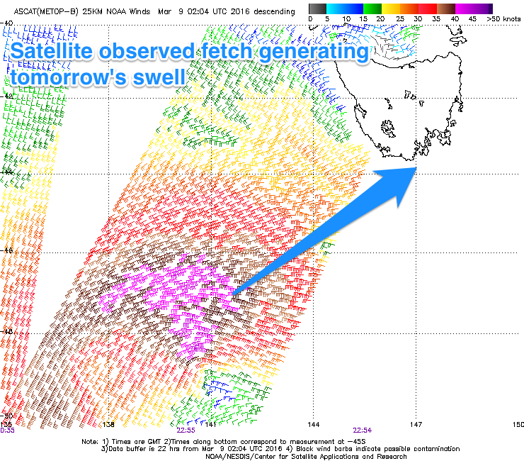
 Our fresh pulse of SW groundswell is still on track, with a strong low currently to our south-west, aiming a fetch of SW tending W/SW gales through our south-western swell window.
This system will pass under us this afternoon and evening producing a fresh pulse of SW swell for tomorrow morning to 2ft to possibly 3ft across Clifton, easing into the afternoon and further back from 1-2ft Friday morning.
Conditions are still looking dicey for the early with a SW breeze, but this should tend variable by mid-morning creating good conditions ahead of afternoon E'ly breezes. Friday should be clean with a N/NW tending N/NE breeze ahead of afternoon sea breezes.
Saturday is still due to be tiny, while Sunday's inconsistent long-range W/SW groundswell is also on track. This swell is being generated by a strong frontal system in our far swell window south-west of WA, producing a fetch of W'ly gales.
Inconsistent 1-2ft waves are due to be seen from this source on Sunday, with offshores ahead of afternoon sea breezes.
Next week onwards (Mar 14 onwards)
A couple of strong poleward tracking frontal systems are due to produce pre-frontal W/NW gales through our swell window through the end of the week and weekend. This will then be followed by a better aligned but weaker post-frontal W/SW fetch on Sunday.
This should produce small pulses of W/SW groundswell for early next week, the first Monday to 2ft, followed by similar sized pulses Tuesday and Wednesday.
Unfortunately a strong onshore change is due Monday, with persistent gusty S/SE winds Tuesday and a poor quality windswell, easing Wednesday as winds swing more E'ly.
We'll have a closer look at this Friday though.

