Small ahead of a good swell Friday
Southern Tasmania Surf Forecast by Craig Brokensha (issued Monday 22nd February)
Best Days: Tuesday morning, exposed breaks Wednesday morning, Friday, Saturday morning, Sunday morning
Recap
A good pulse of new W/SW groundswell was seen Saturday to 2-3ft with offshore winds, easing back from 1-2ft Sunday as favourable conditions were again seen through the morning.
Today was back to a tiny 1-1.5ft with light winds early ahead of S/SE sea breezes.
This week (Feb 23 - 26)
Later today a new SW groundswell should start to show, peaking through tomorrow to 1-2ft from a pre-frontal fetch of W/NW winds over the weekend.
A secondary pulse for Wednesday looks to have been downgraded slightly with tiny 1-1.5ft sets more than likely rather than surf to 2ft.
Good conditions are due with N/NW offshores during the morning tomorrow, likely tending variable into the afternoon. Wednesday morning should be clean again ahead of an afternoon W/SW change.
This change will be related to a strengthening cold front passing under us during the day but no significant swell is expected off this.
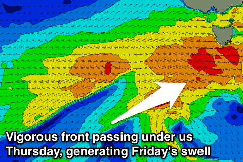
 Of greater importance is a stronger polar frontal progression developing to our west-southwest during the middle of the week.
This progression has been downgraded a touch in strength, with a weakening and broadening fetch of SW gales due to be projected from the polar shelf south of WA, up towards Victoria through our western swell window.
This should produce a fun W/SW groundswell for Friday afternoon, but a secondary front firing up right on our doorstep Thursday evening will generate an additional fetch of W/SW gales right under us,
This should produce a better short-range W/SW swell for Friday to a good 3ft, with a secondary 2-3ft pulse on the cards for Saturday as a secondary weaker front passes under us.
Winds look favourable with all day offshore W/NW breezes Friday and W/NW to W/SW winds Saturday.
Fading surf is then due into Sunday but a good new SW swell is on the cards for Monday as a deep and intense polar low develops later in the week and pushes through our swell window over the weekend. A long-period and strong 2-3ft of W/SW groundswell is due to build Monday from this system, but we'll have another look at this Wednesday.

