Fun weekend, slower next week until late
Southern Tasmania Surf Forecast by Craig Brokensha (issued Friday 19th February)
Best Days: Saturday, Sunday morning, Tuesday and Wednesday mornings, Friday
Recap
Plenty of strong S'ly swell still in the mix yesterday, with onshore winds but just big enough for protected spots.
Today the swell has all but gone with a new SW groundswell in the mix as conditions improved through the day as morning onshores shifted back offshore with an approaching front.
This weekend and next week (Feb 20 - 26)
The front linked to today's shifting winds is linked to a strengthening frontal system currently passing under the state. A fetch of gale to severe-gale W/SW winds are being produced, generating a strong W/SW groundswell for tomorrow to 2-3ft across Clifton, easing back from 2ft on the sets Sunday morning.
Clean conditions are due all day tomorrow with fresh NW tending W/NW winds and N/NW offshores Sunday morning ahead of afternoon sea breezes.
A low point in swell activity is due Monday morning, but a small kick in SW swell later in the day and more so Tuesday is expected from weak polar frontal activity over the weekend. This should provide 1-2ft sets under morning offshores.
A slightly stronger but less favourably aligned front is then due to produce a W/SW pulse for later Tuesday and more so Wednesday but again in the 1-2ft range.
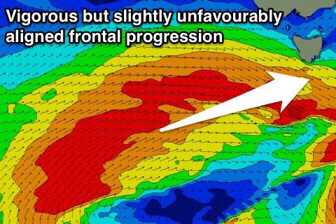
 Of greater importance is a much more significant polar frontal progression firing up to our south-west during the middle to end of next week.
This will be the result of a strong node (peak) of the Long Wave Trough drifting east across us next week.
The only issue is that the frontal activity will be more in our western swell window and aimed towards Victoria/South Australia.
In saying this we should still see moderate sized pulses of W/SW groundswell through Friday and Saturday next week, but more on this Monday. Have a great weekend!

