Strong easing S'ly swell, new good cleaner W/SW swell Saturday
Southern Tasmania Surf Forecast by Craig Brokensha (issued Wednesday 17th February)
Best Days: Thursday morning protected spots, early Friday morning, Saturday morning, Sunday morning
Recap
A strong SW groundswell pushed in yesterday morning across Clifton but with onshore SW winds. A tweak in direction and further kick in size later saw protected locations turn on, continuing into this morning ahead of an easing trend this afternoon.
This week and weekend (Feb 18 - 21)
We've got plenty of S'ly swell left for tomorrow, as the vigorous low responsible for the currently swell continued to project a fetch S/SW gales up through our southern swell window today.
This should produce a final pulse of S'ly groundswell for tomorrow morning, easing from 3-5ft as onshore SW winds persist.
Offshore winds are due into Friday morning from the W/NW, giving into a W/SW change mid-morning as the swell tends S/SE and eases from 2ft or so.
Also in the mix Friday should be a new SW groundswell from a pre-frontal fetch of NW gales, but of greater significance is the swell generated by the front passing under us during the day.
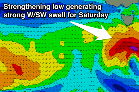
 The swell from this system has been upgraded as the front responsible strengthens under us, generating a fetch of gale to severe-gale W/SW winds and strong W/SW groundswell Saturday morning to a good 3ft across Clifton, easing later and further down from the 2ft range Sunday morning.
Winds Saturday morning are great and from the NW ahead of a W/SW change, NW offshores Sunday ahead of SE sea breezes.
Longer term into next week there's plenty of fun small SW groundswell on the cards from persistent polar frontal activity, but later in the week a much stronger polar frontal progression may generate a larger W/SW groundswell for Friday. Have a check back here Friday for more on this.

