Lots of swell over the coming days but with SW winds
Southern Tasmania Surf Forecast by Craig Brokensha (issued Monday 15th February)
Best Days: Protected spots later Tuesday through Thursday morning, Friday, Saturday morning, Sunday morning
Recap
Good 1-2ft sets were still on offer Saturday morning under offshore winds, while a new pulse of SW swell for Sunday came in at 2ft through the morning, kicking further through the day as winds remained offshore.
This morning a drop in size back to 1-2ft was seen with strengthening NW winds ahead of a strong mid-latitude low.
This week (Feb 16 - 19)
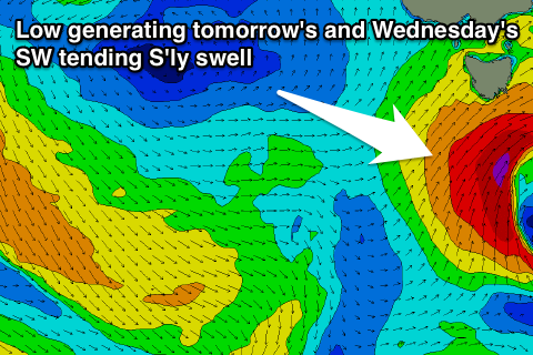
We've got an upgrade in the SW swell due across our region tomorrow, with a relatively weak cold front that was forecast to strengthen under us, now doing so earlier, aiming a fetch of gale-force W/SW winds through our western swell window this morning, with a fetch of SW winds due to be generated under us this evening and early tomorrow morning.
We should see a moderate sized SW groundswell building through tomorrow from this low, reaching 3-4ft through the morning, with the odd bigger set possible later in the day.
Through tomorrow the low will continue moving slowly east while aiming a fetch of gale to severe-gale S/SW winds through our southern swell window, followed by a weaker S'ly fetch projecting north up our east coast Wednesday morning.
 What should result is moderate amounts of S/SW tending S'ly swell through Wednesday, coming in at 4ft through the morning, possibly easing a touch late before easing back from a more noticeable 3-4ft Thursday morning from the S'th.
It's touch and go whether this swell will be big enough for protected locations but winds will be best for these spots with fresh SW breezes through tomorrow, persisting Wednesday and Thursday before swinging back offshore Friday.
Now, into Friday a new SW groundswell is due from a broad fetch of pre-frontal NW gales that are currently south-west of WA. This should keep good 2ft sets hitting Clifton before being replaced by a new short-range W/SW swell Saturday (below).
This weekend onwards (Feb 20 onwards)
A relatively weak but strengthening frontal system passing under us on Friday should produce a fun pulse of short-range SW swell for Saturday coming in at a good 2ft+ across Clifton with morning offshore winds.
Longer term there's nothing too major cards so try and make the most of the dynamic forecasts ahead.

