Good swell building Sunday, easing Monday with S/SW swell for mid-week
Southern Tasmania Surf Forecast by Craig Brokensha (issued Friday 12th February)
Best Days: Sunday once the swell fills in, Monday morning
Recap
Tiny leftover 0.5-1ft sets yesterday morning, with a new small swell for today not really offering much above 1ft unfortunately.
This weekend and next week (Feb 13 - 19)
Clean conditions are due tomorrow morning but the swell will likely remain tiny with 1ft sets across Clifton.
Sunday's new SW has been downgraded a touch with the intense low producing it not being as well structured as it could be, resulting in only a limited kick in size to 2ft+ during the day across Clifton.
Of greater importance is a secondary trailing front producing a reinforcing W/SW swell for Monday morning. This will be the result of a fetch of strong to gale-force W/SW winds racing in and under us through Sunday, keeping 2ft waves hitting Clifton early Monday before easing into the afternoon.
Conditions are due to be clean most of Sunday with NW offshores ahead of a mid-afternoon SW change, with increasing NW winds Monday.
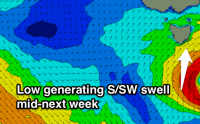
 Moving into the middle of next week another strong front racing in from the west is due to develop into a stronger and stalling low pressure system as an upper cold pool feeds off way warmer than normal sea surface temperatures off our East Coast.
An initial increase in SW swell is expected Tuesday from the front, with the stalling low aiming a fetch of severe-gale to near storm-force S/SW winds through our swell window Tuesday evening, producing a bigger S/SW swell for Wednesday which at this stage looks to be in the 3-4ft range.
Winds are the only issue and likely to be from the SW, but we'll have a closer look at this dynamic system on Monday. Have a great weekend!

