Tiny ahead of fun swells to end the week
Southern Tasmania Surf Forecast by Craig Brokensha (issued Monday 1st February)
Best Days: Thursday morning, Friday morning, Saturday morning, Sunday morning
Recap
Tiny choppy waves to 1ft Saturday, with a touch more size due to a better SW groundswell filling in Sunday, but conditions remained poor.
Today the swell was fading from 0.5-1ft as poor E'ly winds continued.
This week (Feb 2 - 5)
Conditions will improve into tomorrow as winds swing offshore from the N'th but there'll be no significant swell at all with tiny 0.5-1ft sets across Clifton.
Wednesday will remain tiny, but into Thursday and Friday we've got some decent swell on the cards.
An intense mid-latitude low has formed south of Western Australia, with a fetch of severe-gale to storm-force W/SW winds being generated too far north of our swell window.
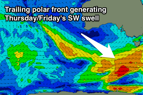
 This low is forecast to drift south-east and closer to us tomorrow before a polar front fires up on its tail, aiming a fetch of SW gales through our south-western swell window Wednesday.
This should produce a fun pulse of SW groundswell for Thursday to 2ft, with a secondary similar sized pulse for Friday from the tail of the trailing front.
Morning W/NW winds are due, shifting onshore from the SW each day.
This weekend onwards (Feb 6 onwards)
Friday's swell should ease back through Saturday from a clean 1-2ft, with a small reinforcing SW groundswell for Sunday from an intense but late forming polar low to our south-west Friday evening. Inconsistent 1-2ft sets should persist across Clifton, before fading into Monday.
Longer term, tiny amounts of SW swell are due into most of next week from weak but persistent polar frontal activity along the polar shelf. More on this Wednesday though.

