Easing S/SE swell with average winds, cleaner but smaller from Saturday
Southern Tasmania Surf Forecast by Craig Brokensha (issued Wednesday 13th January)
Best Days: Spots that handle a westerly and open to the S/SE swell tomorrow, early Friday protected spots, Saturday, Sunday and Monday mornings for small to tiny peelers
Recap
Small clean waves again yesterday, while today a mix of new SW and building S/SE groundswell offered 2ft sets this morning. A further kick in size was expected this afternoon as hot fresh N'ly winds persisted.
This week and weekend (Jan 14 – 17)
Today's S/SE groundswell should ease back through tomorrow from 2ft+ across Clifton with 3ft+ sets at more exposed breaks as early W'ly winds swing W/SW around dawn and SW through the day as an intense mid-latitude low pushes across us.
This low should produce a small pulse of SW groundswell, tending S/SW while easing into the afternoon.
2ft to nearly 3ft sets are expected early, easing to 2ft into the afternoon and further back to 1-1.5ft Saturday morning.
Fresh SW winds are due to continue Friday, but there's a slim chance for an early W'ly, while Saturday morning will be clean with a morning NW'ly.
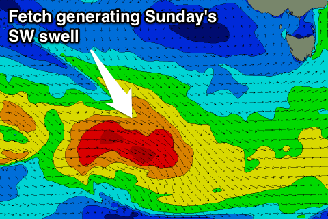
 Into Saturday afternoon and more so Sunday a new pulse of SW groundswell is expected from a pre-frontal fetch of strong W/NW winds and then tight low producing gale to severe-gale W'ly winds.
Fun 2ft waves are due across Clifton under morning NW offshores and afternoon SE sea breezes.
Into next week the swell will fade with favourable N'ly winds, and unfortunately there's nothing too significant due in the longer term. We'll have another look at this Friday though.

