Average end to the week, fun Saturday and Monday
Southern Tasmania Surf Forecast by Craig Brokensha (issued Wednesday 4th Novemer)
Best Days: Saturday morning, Sunday morning, Monday
Recap
A fresh pulse of S/SW swell expected yesterday failed to really come in through the morning with bumpy 1-2ft waves under a light to moderate onshore breeze. The afternoon may have provided more size, but a secondary pulse of S'ly swell this morning has come in better with 2-3ft sets across Clifton under offshore tending NE winds.
This week and weekend (Nov 5 - 8)
This morning's S'ly groundswell pulse is expected to fade overnight, easing back from a small to tiny 1-1.5ft. Early fresh N/NW winds are again expected to swing N/NE mid-morning and strengthen.
Into Friday our good new pulse of inconsistent SW groundswell is still on track, biggest into the afternoon to 2ft+. Unfortunately so are the onshore winds with a change due around dawn, bringing S/SW onshores.
Saturday will see the swell easing back from 2ft with cleaner conditions under morning NW winds ahead of another onshore S'ly change late morning.
The strength of this change has been downgraded in recent model updates, and no considerable windswell is due off it, with fading surf Sunday under NW offshores.
 Next week onwards (Nov 9 onwards)
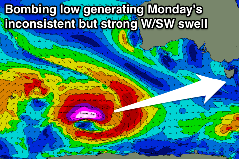
From the start of next week we've got plenty of fun swell on the way. The first will be a long-period strong but inconsistent W/SW groundswell, generated as a low 'bombs' in the south eastern Indian Ocean tomorrow. This low will drop over 24hPa in 24 hours from 980hPa to 936hPa, with a fetch of storm to hurricane-force W/SW winds being generated in our swell window.
The long-period fore-runners to 23s are due to arrive across the West Coast later Sunday afternoon but with no major size attached. The groundswell should fill in Monday and build to an inconsistent 2ft to occasionally 3ft across Clifton with favourable NW winds through the morning and possible SE sea breezes.
In the wake of the 'bombing low' secondary weaker polar frontal activity moving through our swell window during the weekend and early next week should produce reinforcing W/SW swells in the 2ft range through Tuesday and Wednesday. Winds look to become poor though in the wake of S/SE change Tuesday, persisting from the E Wednesday. More on this Friday though.

