Fun weekend, very slow next week
Southern Tasmania Surf Forecast by Craig Brokensha (issued Friday 7th August)
Best Days: Saturday, Sunday morning, Monday afternoon exposed spots
Recap
Solid easing SW groundswell from 3-4ft across Clifton yesterday morning with early workable winds, while today the swell was back to a smaller 2-3ft but with bumpy conditions under an early W/SW'ly. A strong new swell is due later today from the S/SW to 3ft+ but winds will likely be onshore.
This weekend and next week (Aug 8 - 14)
 This afternoon's late kick in S/SW groundswell should be reinforced by a secondary pulse tomorrow morning, generated by a strong polar front currently to our south, which is moving off to the east. 3ft sets should continue across Clifton before easing back into the afternoon and further from 2ft Sunday morning.
Winds should be good and light NW tending variable tomorrow and then N/NW tending N'ly winds Sunday.
Monday afternoon's inconsistent long-range W/SW groundswell is still on track, with the vigorous but distant polar low in the southern Indian Ocean, currently weakening to the south-southwest of WA.
Clifton should kick to an infrequent 1-2ft through the day with N'ly tending N/NE winds, favouring more exposed locations.
Unfortunately the westerly swell activity due mid-week has been downgraded, with the frontal activity under the country now due to take the form of a couple of cut-off lows, pushing too north through the Bight and out of our swell window.
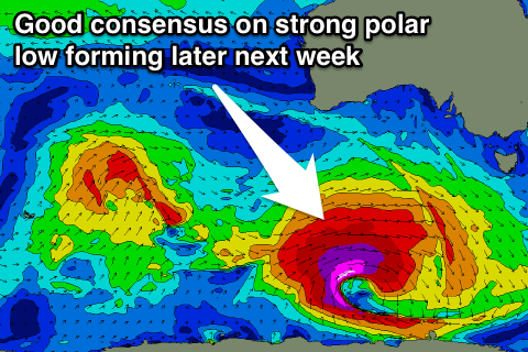
Longer term there's good model consensus that a very strong and powerful polar low will fire up under the country later next week possibly generating a large SW groundswell for the following weekend. More on this Monday though. Have a great weekend!

