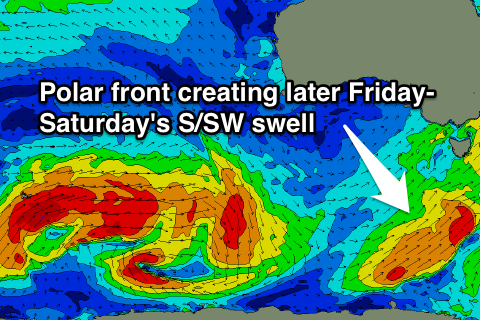
Easing swell with early favourable winds, fun weekend
Southern Tasmania Surf Forecast by Craig Brokensha (issued Wednesday 5th August)
Best Days: Early Thursday and Friday, Saturday, Sunday morning
Recap
Easing S/SW swell from a clean 2-3ft yesterday morning, while today the surf started in the 2-3ft range again, but a better increase in SW swell should be seen this afternoon to the 4-5ft range, but winds have just gone W/SW.
This week and weekend (Aug 6 - 9)
 The front linked to this afternoon's pulse of SW swell is still aiming a fetch of strong to near gale-force SW winds up into us and this should slow the easing trend in size through tomorrow, from 3-5ft early across Clifton.
Come Friday morning the swell should be back to a smaller 2-3ft.
A final polar fetch of S/SW gales firing up in our southern swell window tomorrow should generate an afternoon pulse of S'ly groundswell back to the solid 3ft+ range.
A slow drop in size is then due through the weekend, back from 3ft out of the S'th Saturday and further down from 2ft Sunday.
Winds over the coming days will be average with an early W'ly tending SW breeze tomorrow and then similar W'ly tending SW winds Friday.
Saturday looks best with light NW winds, tending light to moderate SE into the afternoon. Sunday will then be offshore all day with N/NW tending variable winds.
Next week onwards (Aug 10 onwards)
There's nothing too major on the cards for early next week with an infrequent long-range W/SW groundswell from an Indian Ocean storm only due to come in at 1-2ft Monday.
Mid to late next week we should see some stronger frontal activity fire up in our western swell window but it'll be mostly W/SW groundswell. We'll have a closer look at this again Friday.

