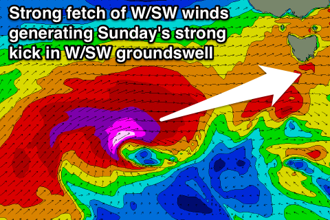
Easing surf, with a strong W/SW swell Sunday
Southern Tasmania Surf Forecast by Craig Brokensha (issued Wednesday 29th July)
Best Days: Every day over the coming period
Recap
Monday's strong kick in swell eased back rapidly as expected leaving smaller 2ft waves across the coast yesterday morning. Today the surf was a smaller and clean 1-2ft ideal for most surfing abilities.
An afternoon kick in strong SW groundswell was seen though with better surf for experienced surfers into this evening.
This week and weekend (Jul 30 – Aug 2)
This afternoon's strong kick in SW groundswell is due to ease back through tomorrow, with 3ft sets early, smaller into the afternoon and only 1-2ft or so Friday.
Winds should remain favourable and offshore from the NW-NNW.
 Our run of strong W/SW groundswell from Saturday is still on track, but the storm track will stay just a little too far west and north than ideal for us in its early stages.
This evening a strong polar front will form south-west of WA and project north-east through our western swell window up towards Victoria over the coming days before crossing us Saturday.
A moderate sized W/SW groundswell should be generated, building Saturday from a small 1-2ft through the morning, towards 2-3ft later in the day and peaking Sunday morning to the 3ft range.
Racing in quickly behind this initial front, with be a stronger system generating a fetch of severe-gale to storm W/SW winds through our western swell window, on an already active sea state.
A larger W/SW groundswell pulse should result, building strongly Sunday afternoon and reaching 4-5ft across Clifton, much much larger at more exposed spots.
This swell should then drop into Monday from 3-4ft or so ahead of another pulse of W/SW groundswell Tuesday. WInds look generally good for protected spots and from the NW-W/NW.
Tuesday's swell looks dicey with the frontal system generating it pushing straight up towards South Aus, and not well through our swell window at all. This will probably only result in 2-3ft of swell Tuesday morning, easing into the afternoon. Some small S/SW swell will also be in the mix to a similar size, from a stationary fetch of S/SW gales at the pole, but we'll confirm this Friday.
Longer term the strong node of the Long Wave Trough responsible for all the swell action over the weekend will push further east and aim the frontal activity up and into us through the middle to end of next week. More on this Friday though!

