Lots of swell to come over the period
Southern Tasmania Surf Forecast by Craig Brokensha (issued Monday 27th July)
Best Days: Tuesday morning, Wednesday afternoon, Thursday, the weekend onwards
Recap
Tiny waves Saturday and Sunday with the low bringing large waves to the West Coast and Victoria but being too north to generate any swell for Clifton.
Into today though, the low moved across us and aimed a stronger than forecast fetch of severe-gale to storm-force S/SW winds into the South Arm, kicking up solid 6ft sets across Clifton, with good waves in protected locations.
 This week and weekend (Jul 28 – Aug 2)
Today's large pulse of S/SW groundswell should ease back rapidly overnight with the low moving off quickly to the east and out of our swell window.
Small fading 2ft waves are due with W/NW winds, tending W/SW into the afternoon.
Our good pulses of SW groundswell for Wednesday have both been brought forward a touch, with a vigorous polar low currently generating a fetch of severe-gale W'ly winds in our south-western swell window.
Both swells should kick strongly Wednesday afternoon, reaching 3-4ft across Clifton, peaking overnight and then easing into Thursday from 3ft or so. Winds will be great with offshore N/NW breezes all day Wednesday and stronger N/NW winds Thursday.
Friday is due to remain small with an onshore change overnight not having any real fetch length behind this, but we'll confirm this Wednesday.
Into this weekend we've got a very active but tricky forecast period ahead.
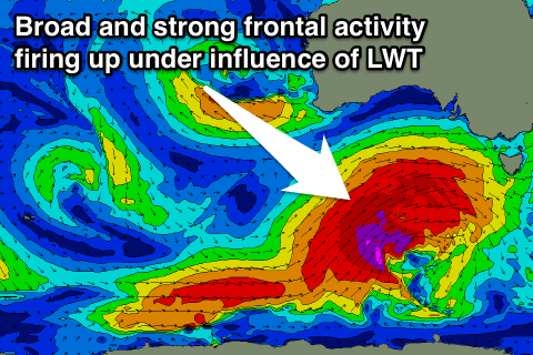
A strong node of the Long Wave Trough is due to move across us later this week and stall through the weekend, projecting front after front up through our swell window.
All the frontal activity looks to be in our western swell window at this stage, with various pulses of W/SW groundswell from Saturday afternoon/evening through until Tuesday.
Size wise we're probably looking at 3-5ft at the peak of each pulse, but we'll have a closer look at this Wednesday.

