Plenty of swell with generally good winds
Southern Tasmania Surf Forecast by Craig Brokensha (issued Monday 29th June)
Best Days: Later Tuesday, Wednesday, early Thursday, Friday, Saturday morning, Sunday
Recap
A very interesting and relatively on forecast weekend of waves, especially due to its tricky nature.
An initial pulse of inconsistent W/SW groundswell came in at a good 2-3ft across Clifton during the morning, a touch ahead of schedule.
This was backed up by a better and bigger swell Sunday morning in the 4ft range, but the larger and stronger increase in W/SW groundswell due into the afternoon from an intense polar low generating storm-force W'ly winds through our swell window, came in with a bang!
Clifton maxed out in the 6ft range (a touch above the forecast 4-5ft+ but in line with model forecasts), while other spots were the biggest they've been in quite some time with favourable winds.
This morning things were more settled with a smaller but still strong and clean 3ft of swell.
 This week and weekend (Jun 30 – Jul 5)
Today's swell should continue to ease into tomorrow morning, with smaller 2ft+ surf due across Clifton in the morning.
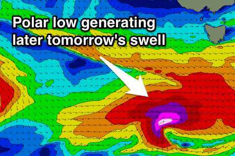
A strong late afternoon kick in new W/SW groundswell is still on track, with a deepening polar low to our south-west currently generating a fetch of pre-frontal W/NW gales, with storm-force W/SW winds at its core.
This should produce a strong and late kick in W/SW groundswell to 3-4ft across Clifton, peaking overnight and then easing steadily from 3ft or so Wednesday morning.
Conditions look good with a NW-W/NW breeze tomorrow and persistent NW'ly Wednesday.
Into the end of the week and weekend, we've got plenty of swell on the cards, as a node of the Long Wave Trough strengthens over us and sits just to our east, directing a series of vigorous polar lows up and into us from Wednesday through the weekend.
An initial system will push in from the west, with a fetch of gale to severe-gale W/SW tending SW winds aimed through our swell window, with a drawn out fetch of S/SW gales to the polar shelf on its tail.
A moderate sized W/SW tending SW groundswell is due from this system, peaking Thursday to 3-4ft across Clifton, with the swell easing slowly Friday from 3ft or so, ahead of an afternoon S/SW groundswell from the polar fetch. This should keep the surf around 3ft before easing into Saturday. Winds on Thursday look a little dicey with an early W'ly likely due to swing fresh to strong SW with the passing of the swell generating front. Friday then looks great with all day NW winds. Saturday should be clean early with a NW'ly ahead of a fresh W/SW change.
Into Sunday a moderate sized SW groundswell is due from a strengthening polar front under us later in the week and through Saturday. While not totally consolidated, we should see a slow moving and healthy fetch of WSW tending SW gales aimed through our swell window.
This should produce a couple of pulses of groundswell, likely in the 3-4ft range with W/NW winds, but we'll have a closer look at this on Wednesday.

