Dicey swell tomorrow, better Wednesday but onshore
Southern Tasmania Surf Forecast by Craig Brokensha (issued Monday 8th June)
Best Days: Tuesday morning (with low expectations), Wednesday protected spots, Thursday, Friday, Saturday morning
Recap
Tiny surf for the most part over the weekend ideal for beginners, while today a kick in new W'ly swell has come in at a better 2ft under strong offshore winds.

This week (Jun 9 – 12)
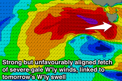
Tomorrow is now more concerning for me regarding swell potential, with the storm-force winds that were forecast to be generated in our swell window Friday not due to happen any more, and the vigorous and deepening frontal system pushing in from the west, sitting a touch further north and more out of our swell window.
We're only due to see a short-lived fetch of severe-gale W'ly winds through our swell window today, weaker from the W/SW overnight, but the tail of the frontal progression still looks healthy with a fetch of SW gales due to be generated in our south-western swell window tomorrow before pushing east into Wednesday.
What's expected tomorrow is a very acute W'ly swell in the 3ft+ range across Clifton, with a better SW groundswell late in the day to a similar size, peaking Wednesday morning to 3-4ft+.
This swell will then ease through the afternoon and back to the smaller 2ft range Thursday.
Winds look favourable and strong from the W/NW tomorrow morning before shifting W/SW into the afternoon and then remaining onshore from the SW into Wednesday. There's a very slim chance for an early W'ly but keep an eye on local wind observations.
Thursday will be clean but the swell small with a NW tending W/NW offshore.
A fun swell is due to end the week, generated by a strong and broad pre-frontal fetch of W/NW gales Wednesday and Thursday and this should come in at 2-3ft across Clifton under favourable NW tending W/NW winds.
Into the weekend this swell will fade away, with only small pulses of SW groundswell due into the start of next week. More on this Wednesday though.

