Small to tiny, with a solid pulse for Tuesday
Southern Tasmania Surf Forecast by Craig Brokensha (issued Wednesday 3rd June)
Best Days: Thursday morning, Sunday morning, Monday afternoon, Tuesday when the swell kicks in protected spots, Wednesday morning
Recap
Smaller easing 2-3ft surf Tuesday morning with 1-2ft waves into this morning under offshore winds, which were supposed to be onshore but resisted all day.
This week and weekend (Jun 4 – 7)
There should still be small 1-2ft waves across Clifton tomorrow morning with favourable N/NW tending NE winds, before becoming tiny into Friday.
Saturday is due to remain tiny, with a small acute W'ly swell failing to really get above 1ft.
A slightly better SW groundswell pulse is due Sunday morning, generated by a tight but intense low drifting south-east and through our swell window on Saturday. A short-lived fetch of W/SW gales should kick up a small 1-2ft wave for Sunday morning before fading into the afternoon. Winds should be good as well and offshore from the N/NW tending NW.
 Next week onwards (Jun 8 onwards)
As touched on last update, we'll see the Long Wave Trough move across us early next week and with this the frontal activity aimed more within our swell window.
Two vigorous and strong fronts are due to push in from the west next week, the first generating a fetch of severe-gale W/SW winds under us Sunday, producing a W/SW groundswell for Monday to 2ft+ during the afternoon.
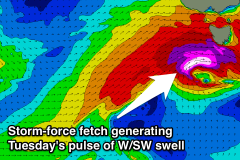
A much stronger pulse is then due Tuesday as a very strong and strengthening front projects a fetch of severe-gale to storm-force W/SW winds quickly through our swell window Monday evening and early Tuesday.
This should produce a strong pulse of W/SW groundswell that is expected to build to 4-5ft through the day before easing quickly out of the SW from the 3-4ft range Wednesday morning.
Winds will be really strong and from the SW but easing Tuesday, creating poor conditions, with offshore NW winds as the swell eases Wednesday.
There'll be plenty of fun waves into the end of the week as a broad but unfavourably aligned frontal systems swings in from the north-west, generating some fun W/SW swell for Friday. More on this in the next update though.

