Fun Saturday, good swells next week with workable winds
Southern Tasmania Surf Forecast by Craig Brokensha (issued Friday 15th May)
Best Days: Saturday, early Sunday, later Monday, Tuesday, later Wednesday, Thursday morning
Recap
Large easing S/SW swell yesterday with onshore winds, favouring protected spots, while today the S/SW swell continued to ease from 2-3ft before a new S/SW groundswell filled in. Conditions were generally average though with fleeting windows of favourable winds in between an onshore flow.

This weekend and next week (May 16 - 22)
Today's pulse in S/SE groundswell is due to ease through tomorrow from 2ft or so only to be replaced by a good pulse pulse of new SW groundswell from a polar low pushing through our swell window the last couple of days.
This should see Clifton kick to 3ft before easing from 2ft Sunday morning.
Winds will become more favourable and swing offshore from the NW to W/NW tomorrow and then NW tending fresher W/NW Sunday.
Before a strong and late kick in new SW groundswell Monday afternoon/evening, a slight kick in W/SW swell from pre-frontal W/NW winds should keep 1-2ft sets hitting Clifton into Monday morning.
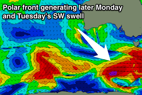
The SW groundswell though, will be generated by a strengthening polar low to our south-west Saturday night and Sunday, aiming a fetch of severe-gale W/SW winds through our south-western swell window.
A strong SW groundswell pulse should be generated, arriving late Monday, kicking to 2-3ft on dark before peaking overnight and easing from 3ft Tuesday morning.
A secondary smaller and less consistent pulse is then due later Wednesday, easing Thursday from a more distant and less favourably aligned polar frontal system developing south of WA Sunday afternoon and evening.
With this a fetch of SW gales will be mainly aimed towards SA, with us seeing a smaller swell spreading towards us.
Clifton should build to 1-2ft on dark Wednesday and then peak Thursday morning to 2-3ft.
Into the end of the week and next weekend a couple of stronger polar fronts were on the cards, but these have been downgraded in the latest update. Instead fun pulses to 2ft or so are expected.
Conditions next week should be generally favourable with N/NW tending NE winds Monday and then N/NW tending N'ly winds Tuesday and N/NW tending N/NE winds Wednesday.
We may see an onshore change through Thursday and Friday with a building windswell, but we'll review this Monday. Have a great weekend!

