Swell rolls on, large mid-late next week
Southern Tasmania Surf Forecast by Craig Brokensha (issued Friday 8th May)
Best Days: Saturday, Sunday morning, Monday in protected spots, Tuesday morning, protected spots Wednesday through Friday
Recap
Good building swell yesterday with strong W/NW winds, while this morning the swell peaked early with 3-5ft sets across Clifton under lighter W/NW winds at dawn. Winds have since strengthened again from the W/NW as the swell dropped back.
 This weekend and next week (May 9 - 15)
Today's SW groundswell is due to ease further overnight but a new W/SW swell will take its place, generated by a vigorous frontal system currently pushing in from the west.
A fetch of W/SW gales are being aimed into us, producing another solid W/SW groundswell tomorrow to 3-4ft+ around the middle of the day/early afternoon.
Winds will improve through tomorrow with a strong but easing W/NW tending NW breeze into the afternoon.
A low point in swell activity is due into Sunday morning ahead of another strong pulse of W/SW groundswell later in the day.
This swell doesn't look to be as strong as Saturday's with a smaller fetch of W/SW gales being generated in our swell window on Sunday, kicking up 3-4ft waves late in the day as winds swing from a strong W/NW'ly around to the W/SW through the afternoon.
A drop in size is due overnight as winds tend NW at dawn but then back to the W shortly after. A new S/SW groundswell may be seen later in the day though from a fetch of S/SW winds wrapping around the southern flank of the low, keeping 2-3ft waves hitting Clifton.
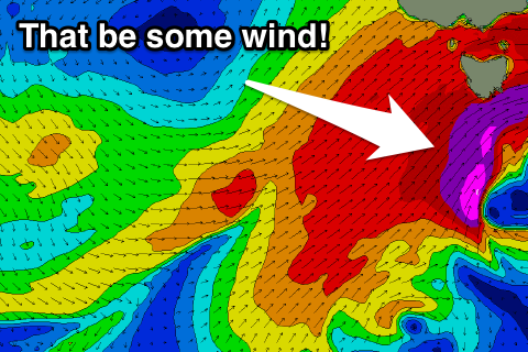
Tuesday morning should be another low point in swell activity but a vigorous polar low pushing in from the west is due to aim a fetch of severe-gale to storm-force W/SW winds on the edge of our western swell window before pushing across us Tuesday.
Behind the initial change though a broad but weaker fetch of SW gales will be aimed towards us, followed by a tertiary S/SW projection Wednesday and Thursday.
This should result in three separate swells, one from the W/SW later Tuesday and Wednesday morning, a better SW pulse Wednesday afternoon and then S/SW swell Thursday and Friday.
Clifton is expected to build to 3-5ft later Tuesday with the SW swell pulse building to 4-6ft Wednesday afternoon, persisting most of Thursday before dropping away Friday.
Winds are expected to be strong from the NW tending gale-force SW Tuesday and then SW most of Wednesday and Thursday. We'll have a closer look at this on Monday though. Have a great weekend!

