Small waves for the most part
Southern Tasmania Surf Forecast by Craig Brokensha (issued Monday 20th April)
Best Days: Tuesday morning, Thursday from late morning, Friday morning, Sunday afternoon
Recap
The weekend came in as expected with a small clean 2ft of swell Saturday morning ahead of a late kick in strong new W/SW groundswell, peaking Sunday morning in the 4ft range across Clifton with morning offshores.
Today was the better day to surf as the swell eased back from 2-3ft under lighter N/NW winds.
 This week (Apr 21 - 24)
Today's swell should continue to drop back from 2ft tomorrow morning with an acute W'ly swell likely to keep sets around that range into the afternoon before fading Wednesday.
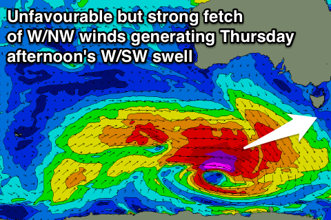
Into Thursday a new inconsistent W/SW groundswell is due, generated by a vigorous polar front that's currently south-west of WA.
This frontal system will be strong but it's track unfavourable with a fetch of severe-gale W/NW winds being aimed more towards the Polar Shelf rather than us.
The strength and breadth of the storm should overcome this slightly, with some small and inconsistent W/SW groundswell spreading radially up towards us and building through Thursday, reaching 2ft+ across Clifton before easing from 2ft Friday morning.
Winds are a little funky with a variable breeze due during the morning before tending more E'ly through the day and then Friday should see N/NW tending N/NE winds.
This weekend onwards (Apr 25 onwards)
The swell should continue to ease into Saturday, while Sunday small kick in long-range W/SW swell is due but with onshore tending offshore winds as a mid-latitude low moves across us.
Behind this we may see some S/SW swell but we'll look at this closer on Wednesday.

