Fun swell Friday, larger swell Sunday
Southern Tasmania Surf Forecast by Craig Brokensha (issued Wednesday 15th April)
Best Days: Friday, Saturday morning, Sunday morning, Monday morning, Tuesday
Recap
Easing S/SE swell from the 2-3ft range yesterday under generally favourable winds with clean smaller 2ft waves today.
 This week and weekend (Apr 16 - 19)
Tomorrow will be a lay day with tiny amounts of swell and W/NW tending NW winds, while into Friday a mix of inconsistent and acute W/SW groundswell along with some shorter-range W/SW swell is due to fill in.
Clifton is only due to be around 2ft through the morning before increasing to 2ft to possibly 3ft through the afternoon.
A drop in size is then due through Saturday from a smaller 2ft. Conditions should be clean all day Friday with moderate to fresh NW winds and then Saturday should see N/NW breezes ahead of an afternoon W/SW change.
Late in the day we should see the fore-runners of a large and powerful W/SW groundswell due Sunday filling in, reaching 3ft by dark but with that onshore wind.
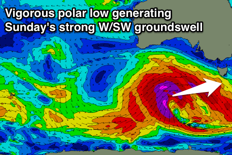
This strong groundswell will be generated by a vigorous and broad polar low firing up south-west of WA tomorrow, aiming a fetch of storm-force W/SW winds through our western swell window while pushing east towards us.
A peak is due Sunday morning with the swell coming in at a solid 3-5ft across Clifton before easing a touch into the afternoon. A secondary weaker front on the tail of the polar low should produce a smaller SW swell for Monday morning, easing from 3-4ft across Clifton.
Winds Sunday should be from the W/NW early creating clean conditions before tending SW through the mid-morning. Monday then looks good with NW winds ahead of an afternoon W/SW change.
Longer term there's nothing significant on the cards until later in the week, but we'll review this Friday.

