Average days ahead, bigger and better weekend
Southern Tasmania Surf Forecast by Craig Brokensha (issued Wednesday 14th January)
Best Days: Saturday, Sunday morning, Monday morning, early Tuesday
Recap
Yesterday saw small clean 1-1.5ft waves across Clifton, with better options further afield as winds strengthened from the NE.
An evening onshore change has strengthened into today with building levels of poor windswell into this afternoon.
This week (Jan 15 -16)
A deepening and strong low sitting off our East Coast is the system responsible for our poor weather and strong onshore winds along with building windswell.
The low will start to push off to the south-east through tomorrow and with this we'll see the fetch of strong S'ly winds weaken and push out of our swell window. This should result in easing levels of S'ly windswell mixed in with some small SE swell from the bottom flank of the low from 2ft to nearly 3ft during the morning. Come Friday there isn't expected to be much left above 1ft.
Winds tomorrow will improve but remain average and fresh and gusty from the W/SW all day, favouring protected locations. Friday will be clean as winds swing back to the N/NW ahead of an afternoon W/NW change.
 This weekend onwards (Jan 17 onwards)
The weekend's strong groundswell event is still on track, with a strong node (peak) of the Long Wave Trough due to intensify across Victoria over the weekend.
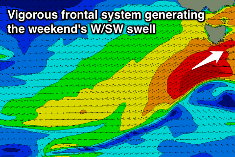
This will steer and feed a strengthening polar front through our western swell window, with a fetch of gale to severe-gale W/SW winds being aimed towards us.
A strong W/SW groundswell should be generated for Saturday, but the front is expected to stall just to our south-west on Saturday, aiming an additional fetch of W/SW gales through our south-western swell window, generating a secondary larger W/SW groundswell pulse for the evening/Sunday morning.
Size wise we should see Clifton building from 2ft early Saturday to 3-5ft during the evening, easing from a similar size Sunday morning.
Winds will be strong but from the W/NW tending W/SW Saturday and then weaker from the W/NW tending SW Sunday. Therefore protected breaks across the South Arm will fare best over the weekend.
A steady drop in size is due into early next week as the swell swings more SW from 2-3ft Monday morning and 1-2ft Tuesday under offshore winds from the northern quadrant.
Longer term there's nothing as significant as what's expected this weekend on the cards, so make the most of it.

