Fun Thursday, solid and offshore Sunday
Southern Tasmania Forecast (issued Wednesday 8th October)
Best Days: Thursday morning, Sunday, Monday
Recap
Yesterday was average with poor winds and a small swell. Today light offshores winds created better conditions with a fun swell to 1-2ft. A late kick in new W/SW swell should have been see to a better 2ft across the region.
This week (Oct 9 - 10)
This afternoon's kick in W/SW groundswell should be replaced by a better SW swell tomorrow morning to 2ft+ across Clifton, generated to our south-west yesterday.
Conditions should be good with a moderate NW tending W/NW breeze, but the morning will be the pick with the most size. Come Friday there isn't expected to be any major size left with easing 1ft+ waves under N/NE tending variable winds.
 This weekend onwards (Oct 11 onwards)
Saturday morning will start out tiny under fresh NW tending W/NW winds, but into Sunday our strong W/SW groundswell is still on track, but winds are still moving around a bit.
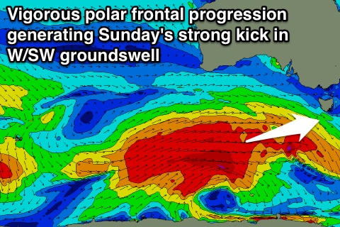
A vigorous and broad polar frontal progression moving in from the west over the coming days should produce a fetch of gale to severe-gale W/SW winds in our swell window, producing a strong W/SW swell that should fill in Saturday and build from the 3ft range early to 3-5ft into the late afternoon.
Winds at this stage are looking good for spots that like northerly winds with a fresh N/NW tending N/NE breeze Sunday and then NW tending variable winds Monday. There's a bit of movement around this though due to the models diverging on a trough moving in from the west, so check back here for the latest update on Friday.

