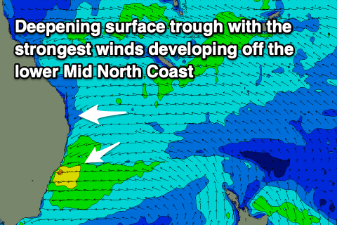
Tricky outlook as a coastal trough deepens
South-east Queensland and Northern NSW Forecast by Craig Brokensha (issued Wednesday April 3rd)
Best Days: Saturday morning from about north of Coffs, Sunday morning, Monday morning, Tuesday morning
Features of the Forecast (tl;dr)
- Building E-E/NE windswell Fri with light morning offshores from SWR north, strong E/NE to the south
- Large, stormy E/NE swell on the lower MNC Sat with strong N/NE-NE winds
- Small-moderate E'ly swell building across northern locations Sat PM, further Sun PM, easing slowly Mon
- Moderate N/NW tending strong N/NE winds Sat
- NW tending NE winds Sun
- W/SW-SW winds Mon AM to about Byron, shifting S/SE into the PM. NW tending NE winds north of Byron
- NW tending NE winds Tue with easing E swell
- Small, easing E swell Wed with strong SW tending S/SE winds
Recap
A fun mix of easing S’ly and E’ly swell favoured exposed beaches yesterday morning, tiny into today and deteriorating into the afternoon as a surface trough slides up from the south.
This week and next (Apr 4 - 12)
Today’s trough will be the catalyst for a much more significant weather system developing across northern NSW over the coming days, with it feeding into a broad area of inland instability.
This will bring strengthening E/NE winds that will be strongest across the lower Mid North Coast, kicking up building levels of E’ly windswell through Friday/Saturday that should mature into mid-period energy on the weekend.
Ahead of this, tomorrow looks to be a lay day with tiny surf and early light winds that will strengthen from the S/SE-SE.
Friday will be tricky, with locations north of the trough, (South West Rocks and north) due to see light morning offshores, with strong E/NE winds to the south. It’ll be stormy and poor south of the troughs axis, with peaky offerings in the 1-2ft range, increasing more towards 2ft+ into the afternoon as strong NE winds kick in across all locations.

Into the weekend, we’ll see battling N/NW tending N/NE (strong) winds across most locations as the trough continues sliding south, but with no real low pressure centre forming, resulting in the unfavourable winds.
Better levels of mid-period E/NE-NE swell look to fill in from the Coral Sea, building Saturday afternoon but peaking in strength through Sunday afternoon and Monday.
Size wise the Gold Coast should reach 4ft on the sets.
The Mid North Coast is likely to peak in size late Friday/Saturday morning with localised levels of swell to 5-6ft+.
The big question is when will we see the trough peel away from the coast, and this looks to be slowly through Sunday but most likely Monday.
With this, Sunday looks to offer NW offshores ahead of NE sea breezes, with Monday offering great W/SW-SW winds in the morning (reaching about Byron ), shifting S/SE into the afternoon, with NW tending NE winds across south-east Queensland.
Winds still look NW Tuesday across the Gold Coast as the E’ly swell slowly drops, smaller Wednesday with gusty SW tending S/SE winds.
Longer term, we’re then looking at an extended run of S’ly swells from late week into next weekend across northern NSW as a strong node of the Long Wave Trough sets up camp across the southern Tasman Sea. More on this Friday.


Comments
Well that's shit. Is it spring all of a sudden?
Thanks Craig. Obviously a bit smaller, but how do you see it playing out size wise on the Sunny Coast around Alex this weekend? Here until Tuesday PM.
North of Brisbane? How dare you. /s
Small, shit and crowded with old goats like always
Yeah it's looking a tad smaller than locations further to the south but there should be plenty trade-swell in the 3ft+ range from Saturday afternoon through Tuesday morning.
Thanks mate, should find something up here then.
is it spring already LOL
94mm in the gauge here o/night.
100-200 in the Lismore catchments.
Nervous times.
I’ve got a feeling that we will maybe bear the brunt of even more.
Last time that happened I binge watched the Godfather movies whilst slowly getting pissed. So it wasn’t all bad.
Still upset at Fredo’s betrayal.
Fingers crossed for that ten foot South swell on the ( fantasy) surf forecast due about the 10th.
It’s the Obi Wan Kenobi swell as far as any chance of creative destruction defeating the evil Empire of dogshit sandbanks around here.
?si=1YSEyBqkW1y3ajIhto this untrained eye it looks like another "river in the sky" scenario playing out. fingers crossed the rain is evenly spread and catchments can handle it
Minor flooding around Lismore - the bottom carpark under sportspower is under water.
sheeeet. again! poor Lismore
Only quite low lying spots adjacent to the river at the moment. River would need to rise a few more meters to become problematic (think its around 4.5m at the moment).
Another 3" in the wilson's catchment since 9am